
Fai una donazione
Equipaggiati per la tua prossima avventura:
In qualità di Affiliato Amazon, questo sito riceve una commissione sugli acquisti idonei, senza costi aggiuntivi per l’utente.
Mappa topografica Egypt
Clicca sulla mappa per visualizzare l'altitudine.
Fai una donazione
Equipaggiati per la tua prossima avventura:
In qualità di Affiliato Amazon, questo sito riceve una commissione sugli acquisti idonei, senza costi aggiuntivi per l’utente.
A proposito di questa mappa
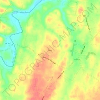
Nome: Mappa topografica Egypt, altitudine, rilievo.
Luogo: Egypt, Jefferson County, West Virginia, 25430, United States (39.33204 -77.96750 39.37204 -77.92750)
Altitudine media: 151 m
Altitudine minima: 118 m
Altitudine massima: 177 m
Fai una donazione
Equipaggiati per la tua prossima avventura:
In qualità di Affiliato Amazon, questo sito riceve una commissione sugli acquisti idonei, senza costi aggiuntivi per l’utente.
Altre mappe topografiche
Clicca su una mappa per visualizzarne la topografia, l'altitudine e il rilievo.
Charles Town
United States > West Virginia > Jefferson County
Due to its low elevation for West Virginia, Charles Town is on the northern extent of the Humid Subtropical climate zone, having cool to mildly cold winters and hot and humid summers. Precipitation is evenly distributed throughout the year, providing lush, abundant plant growth.
Altitudine media: 150 m
Harpers Ferry
United States > West Virginia > Jefferson County
The town was "easy to seize, and hard to hold", because of its topography: surrounded on three sides by high ground – Bolivar Heights to the west, Loudoun Heights to the south, and Maryland Heights to the east – and surrounded by the Potomac and Shenandoah Rivers, anyone who controlled the heights…
Altitudine media: 174 m
Fai una donazione
Equipaggiati per la tua prossima avventura:
In qualità di Affiliato Amazon, questo sito riceve una commissione sugli acquisti idonei, senza costi aggiuntivi per l’utente.
Charles Town
United States > West Virginia > Jefferson County
Due to its low elevation for West Virginia, Charles Town is on the northern extent of the Humid Subtropical climate zone, having cool to mildly cold winters and hot and humid summers. Precipitation is evenly distributed throughout the year, providing lush, abundant plant growth.
Altitudine media: 150 m
Harpers Ferry
United States > West Virginia > Jefferson County
The town was "easy to seize, and hard to hold", because of its topography: surrounded on three sides by high ground (Bolivar Heights to the west, Loudoun Heights to the south, and Maryland Heights to the east) and the Potomac and Shenandoah Rivers, anyone who controlled the heights controlled the city.
Altitudine media: 174 m
Fai una donazione
Equipaggiati per la tua prossima avventura:
In qualità di Affiliato Amazon, questo sito riceve una commissione sugli acquisti idonei, senza costi aggiuntivi per l’utente.
Harpers Ferry
United States > West Virginia > Jefferson County
The town was "easy to seize, and hard to hold", because of its topography: surrounded on three sides by high ground (Bolivar Heights to the west, Loudoun Heights to the south, and Maryland Heights to the east) and the Potomac and Shenandoah Rivers, anyone who controlled the heights controlled the city.
Altitudine media: 174 m