
Mappa topografica Dubuque County
Mappa interattiva
Clicca sulla mappa per visualizzare l'altitudine.
A proposito di questa mappa
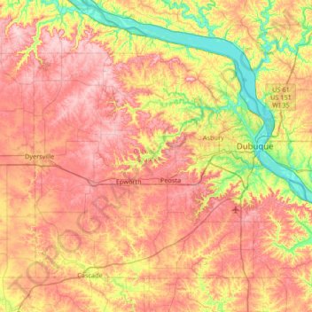
Nome: Mappa topografica Dubuque County, altitudine, rilievo.
Luogo: Dubuque County, Iowa, United States (42.29334 -91.13344 42.67462 -90.47332)
Altitudine media: 284 m
Altitudine minima: 180 m
Altitudine massima: 381 m
The county seat is Dubuque, Iowa, which is located along the Mississippi River in the east-central portion of the county. Eastern Dubuque County is markedly different from the western portion in that its topography is very uneven. The city of Dubuque and surrounding areas adjacent to the Mississippi River have many steep hills, bluffs, and ravines. Also, the eastern portion is more heavily wooded than the west, which is mostly rolling farmland.
Altre mappe topografiche
Clicca su una mappa per visualizzarne la topografia, l'altitudine e il rilievo.
Dubuque
United States > Iowa > Dubuque County
Dubuque, Dubuque County, Iowa, United States
Altitudine media: 241 m
Mississippi River
United States > Iowa > Dubuque County > Dubuque > Eagle Point
Mississippi River, Eagle Point, Dubuque, Dubuque County, Iowa, 52001, United States
Altitudine media: 200 m
Mines of Spain State Recreation Area
United States > Iowa > Dubuque County > Dubuque
Mines of Spain State Recreation Area, Dubuque, Dubuque County, Iowa, United States
Altitudine media: 217 m
Holy Cross
United States > Iowa > Dubuque County
Holy Cross, Dubuque County, Iowa, United States
Altitudine media: 355 m
Farley
United States > Iowa > Dubuque County
Farley, Dubuque County, Iowa, 52046, United States
Altitudine media: 335 m
Epworth
United States > Iowa > Dubuque County
Epworth, Dubuque County, Iowa, 52045, United States
Altitudine media: 310 m