
Mappa topografica Schnecksville
Mappa interattiva
Clicca sulla mappa per visualizzare l'altitudine.
A proposito di questa mappa
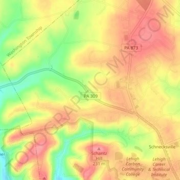
Nome: Mappa topografica Schnecksville, altitudine, rilievo.
Altitudine media: 197 m
Altitudine minima: 144 m
Altitudine massima: 229 m
According to the U.S. Census Bureau, Schnecksville has a total area of 2.7 square miles (7.0 km2), of which 0.01 square miles (0.02 km2), or 0.28%, are water. Schnecksville sits on a ridge at an elevation of about 660 feet (200 m) above sea level. To the west, water flows to Jordan Creek, while to the east water flows to Coplay Creek. Both creeks are southeast-flowing tributaries of the Lehigh River and part of the Delaware River watershed.
Altre mappe topografiche
Clicca su una mappa per visualizzarne la topografia, l'altitudine e il rilievo.
Neffs
United States > Pennsylvania > Lehigh County > North Whitehall Township
Neffs, North Whitehall Township, Lehigh County, Pennsylvania, 18065, United States
Altitudine media: 208 m
Laurys Station
United States > Pennsylvania > Lehigh County > North Whitehall Township
Laurys Station, North Whitehall Township, Lehigh County, Pennsylvania, 18059, United States
Altitudine media: 152 m