
Fai una donazione
Equipaggiati per la tua prossima avventura:
In qualità di Affiliato Amazon, questo sito riceve una commissione sugli acquisti idonei, senza costi aggiuntivi per l’utente.
Mappa topografica Cold Mountain
Clicca sulla mappa per visualizzare l'altitudine.
Fai una donazione
Equipaggiati per la tua prossima avventura:
In qualità di Affiliato Amazon, questo sito riceve una commissione sugli acquisti idonei, senza costi aggiuntivi per l’utente.
A proposito di questa mappa
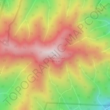
Nome: Mappa topografica Cold Mountain, altitudine, rilievo.
Luogo: Cold Mountain, Haywood County, North Carolina, United States (35.40950 -82.85629 35.40960 -82.85619)
Altitudine media: 1’494 m
Altitudine minima: 1’092 m
Altitudine massima: 1’814 m
Fai una donazione
Equipaggiati per la tua prossima avventura:
In qualità di Affiliato Amazon, questo sito riceve una commissione sugli acquisti idonei, senza costi aggiuntivi per l’utente.
Altre mappe topografiche
Clicca su una mappa per visualizzarne la topografia, l'altitudine e il rilievo.
Waynesville
United States > North Carolina > Haywood County
Most of the town of Waynesville lies between 2,600 and 3,000 feet (790 and 910 m) above sea level, in a valley among 5,000-to-6,410-foot (1,520 to 1,950 m) mountain peaks. With the high Great Balsam Mountains to the west-southwest, and the Plott Balsams to the west-northwest, a handful of peaks over 6000' in…
Altitudine media: 921 m
Fai una donazione
Equipaggiati per la tua prossima avventura:
In qualità di Affiliato Amazon, questo sito riceve una commissione sugli acquisti idonei, senza costi aggiuntivi per l’utente.
Waynesville
United States > North Carolina > Haywood County
Most of the town of Waynesville lies between 2,600 and 3,000 feet (790 and 910 m) above sea level, in a valley among 5,000-to-6,410-foot (1,520 to 1,950 m) mountain peaks. With the high Great Balsam Mountains to the west-southwest, and the Plott Balsams to the west-northwest, a handful of peaks over 6000' in…
Altitudine media: 921 m
Cataloochee Valley Viewpoint
United States > North Carolina > Haywood County > Cataloochee
Altitudine media: 1’058 m
Fai una donazione
Equipaggiati per la tua prossima avventura:
In qualità di Affiliato Amazon, questo sito riceve una commissione sugli acquisti idonei, senza costi aggiuntivi per l’utente.
Fai una donazione
Equipaggiati per la tua prossima avventura:
In qualità di Affiliato Amazon, questo sito riceve una commissione sugli acquisti idonei, senza costi aggiuntivi per l’utente.
Waynesville
United States > North Carolina > Haywood County
Most of the town of Waynesville lies between 2,600 and 3,000 feet (790 and 910 m) above sea level, in a valley among 5,000-to-6,410-foot (1,520 to 1,950 m) mountain peaks. With the high Great Balsam Mountains to the west-southwest, and the Plott Balsams to the west-northwest, a handful of peaks over 6000' in…
Altitudine media: 921 m
Fai una donazione
Equipaggiati per la tua prossima avventura:
In qualità di Affiliato Amazon, questo sito riceve una commissione sugli acquisti idonei, senza costi aggiuntivi per l’utente.