
Mappa topografica Clarkston
Mappa interattiva
Clicca sulla mappa per visualizzare l'altitudine.
A proposito di questa mappa
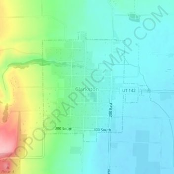
Nome: Mappa topografica Clarkston, altitudine, rilievo.
Luogo: Clarkston, Cache County, Utah, 84305, United States (41.91193 -112.05931 41.92900 -112.03706)
Altitudine media: 1’498 m
Altitudine minima: 1’458 m
Altitudine massima: 1’616 m
The townsite of Clarkston was laid out in 1864. It was named for Israel Justus Clark, who was an early settler and the first branch president of the Church of Jesus Christ of Latter-day Saints in Clarkston. The settlers originally settled east of modern-day Clarkston in a spot known as the flat. Due to water quality concerns and sickness, they moved the town to a higher elevation and closer to City Creek and other springs. They also experimented in dry farming, mainly north of town. There was trouble with the native Americans, and in 1866 the settlement was abandoned for a short time. Eventually, an agreement was made between the settlers and Indian John, a chief under the Washakie. A Latter-day Saint ward was organized in Clarkston in the fall of 1867 with William F. Rigby as bishop. A brick meetinghouse was built in 1910. In 1930 Clarkston had a population of 570. Among the first settlers were Israel J. Clark, James Myler, William Ricks, Michael Poulsen, Johannis Dahle, Gideon Harmison, David Cook, John Griffiths, John Griffin, John Godfrey, Samuel Whitney, Ole S. Jensen and their families; also the Thompson and Hansen families, A. W. Heggie, a Mr. Parker, Paul Paulson, Andrew McCombs, Simon Smith, Isaac Cook, A. H. Atkinson, and others. The existence of the Clarkston settlement was threatened in 1869 when a majority of the settlers, due mainly to discouragement because of the severe winters and heavy drifting snow, decided to move to the present site of Newton, Utah. But a few people decided to stay in Clarkston, and some who had left returned, and the settlement became a permanent one. There was a controversy over retaining the name Clarkston for the original settlement or transferring it to the "New Town."
Altre mappe topografiche
Clicca su una mappa per visualizzarne la topografia, l'altitudine e il rilievo.
Logan
United States > Utah > Cache County
Logan, Cache County, Utah, United States
Altitudine media: 1’498 m
Trenton
United States > Utah > Cache County
Trenton, Cache County, Utah, 84338, United States
Altitudine media: 1’392 m
Benson
United States > Utah > Cache County
Benson, Cache County, Utah, United States
Altitudine media: 1’442 m
Peter
United States > Utah > Cache County > Petersboro
Peter, Petersboro, Cache County, Utah, United States
Altitudine media: 1’445 m
Lewiston
United States > Utah > Cache County
Lewiston, Cache County, Utah, 84320, United States
Altitudine media: 1’376 m
Hyrum
United States > Utah > Cache County
Hyrum, Cache County, Utah, 84319, United States
Altitudine media: 1’439 m
River Heights
United States > Utah > Cache County
River Heights, Cache County, Utah, United States
Altitudine media: 1’395 m
Mendon
United States > Utah > Cache County
Mendon, Cache County, Utah, United States
Altitudine media: 1’399 m
Smithfield
United States > Utah > Cache County
Smithfield, Cache County, Utah, 84335, United States
Altitudine media: 1’404 m
Mount Pisgah
United States > Utah > Cache County
Mount Pisgah, Cache County, Utah, United States
Altitudine media: 1’862 m
Logan Canyon
United States > Utah > Cache County
Logan Canyon, Cache County, Utah, 84322, United States
Altitudine media: 1’780 m
Nibley
United States > Utah > Cache County
Nibley, Cache County, Utah, United States
Altitudine media: 1’428 m
Logan River
United States > Utah > Cache County
Logan River, Cache County, Utah, United States
Altitudine media: 1’919 m
Providence Canyon
United States > Utah > Cache County
Providence Canyon, Cache County, Utah, 84332, United States
Altitudine media: 1’829 m
Wellsville
United States > Utah > Cache County
Wellsville, Cache County, Utah, 84339, United States
Altitudine media: 1’545 m
Logan
United States > Utah > Cache County > Logan > Logan
Logan, Cache County, Utah, 84321, United States
Altitudine media: 1’419 m
Hyde Park
United States > Utah > Cache County
Hyde Park, Cache County, Utah, 84318, United States
Altitudine media: 1’418 m
North Logan
United States > Utah > Cache County
North Logan, Cache County, Utah, 84341, United States
Altitudine media: 1’487 m
Hyrum
United States > Utah > Cache County > Hyrum > Hyrum
Hyrum, Cache County, Utah, 84319-1660, United States
Altitudine media: 1’439 m
Peter Sinks
United States > Utah > Cache County
Peter Sinks, Cache County, Utah, United States
Altitudine media: 2’555 m
Providence
United States > Utah > Cache County
Providence, Cache County, Utah, 84332, United States
Altitudine media: 1’434 m
James Peak
United States > Utah > Cache County
James Peak, Cache County, Utah, United States
Altitudine media: 2’550 m