
Fai una donazione
Equipaggiati per la tua prossima avventura:
In qualità di Affiliato Amazon, questo sito riceve una commissione sugli acquisti idonei, senza costi aggiuntivi per l’utente.
Mappa topografica Mooresburg
Clicca sulla mappa per visualizzare l'altitudine.
Fai una donazione
Equipaggiati per la tua prossima avventura:
In qualità di Affiliato Amazon, questo sito riceve una commissione sugli acquisti idonei, senza costi aggiuntivi per l’utente.
A proposito di questa mappa
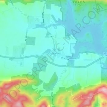
Nome: Mappa topografica Mooresburg, altitudine, rilievo.
Altitudine media: 372 m
Altitudine minima: 316 m
Altitudine massima: 549 m
Fai una donazione
Equipaggiati per la tua prossima avventura:
In qualità di Affiliato Amazon, questo sito riceve una commissione sugli acquisti idonei, senza costi aggiuntivi per l’utente.
Altre mappe topografiche
Clicca su una mappa per visualizzarne la topografia, l'altitudine e il rilievo.
Rogersville
United States > Tennessee > Hawkins County
Rogersville is located slightly southwest of the center of Hawkins County. According to the United States Census Bureau, the town has a total area of 3.4 square miles (8.8 km2), all land. The town is in the valley of Crockett Creek, a southwest-flowing tributary of the Holston River. The elevation of…
Altitudine media: 416 m
Fai una donazione
Equipaggiati per la tua prossima avventura:
In qualità di Affiliato Amazon, questo sito riceve una commissione sugli acquisti idonei, senza costi aggiuntivi per l’utente.
Rogersville
United States > Tennessee > Hawkins County
Rogersville is located slightly southwest of the center of Hawkins County. According to the United States Census Bureau, the town has a total area of 3.4 square miles (8.8 km2), all land. The town is in the valley of Crockett Creek, a southwest-flowing tributary of the Holston River. The elevation of…
Altitudine media: 416 m