
Fai una donazione
Equipaggiati per la tua prossima avventura:
In qualità di Affiliato Amazon, questo sito riceve una commissione sugli acquisti idonei, senza costi aggiuntivi per l’utente.
Mappa topografica Mount Carmel
Clicca sulla mappa per visualizzare l'altitudine.
Fai una donazione
Equipaggiati per la tua prossima avventura:
In qualità di Affiliato Amazon, questo sito riceve una commissione sugli acquisti idonei, senza costi aggiuntivi per l’utente.
Mount Carmel
Sawmill operator, Albert Bradford, gave Mount Carmel its name because of its elevation and beautiful setting in the mountains. He decided that it deserved a special name and named it after the holy mountain in Israel. Mount Carmel began as a logging town. Coal was only discovered in 1790 by Isaac Tomlinson. It took twenty-four years until the first shipment of anthracite was shipped from the borough. Mount Carmel Inn was opened in 1812 by Richard Yarnall and was strategically located on the Centre Turnpike (also known as the Reading-Sunbury Road or Old Reading Road) halfway between Pottsville and Danville. During the latter part of 1854, the Philadelphia and Sunbury Railroad was completed from Shamokin to Mt. Carmel, which led to the opening and development of a number of collieries in the region. During the same year, the Locust Mountain Coal and Iron Company commenced making extensive openings and improvements upon their valuable coal lands in the vicinity of Mt. Carmel, building coal breakers for two collieries – the Coal Ridge and Locust Mountain collieries. The township was erected in 1854, formed from part of Coal Township; by 1862 the borough was incorporated within the township.
Fai una donazione
Equipaggiati per la tua prossima avventura:
In qualità di Affiliato Amazon, questo sito riceve una commissione sugli acquisti idonei, senza costi aggiuntivi per l’utente.
A proposito di questa mappa
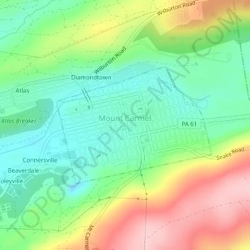
Nome: Mappa topografica Mount Carmel, altitudine, rilievo.
Altitudine media: 380 m
Altitudine minima: 303 m
Altitudine massima: 503 m
Fai una donazione
Equipaggiati per la tua prossima avventura:
In qualità di Affiliato Amazon, questo sito riceve una commissione sugli acquisti idonei, senza costi aggiuntivi per l’utente.
Altre mappe topografiche
Clicca su una mappa per visualizzarne la topografia, l'altitudine e il rilievo.
Dalmatia
United States > Pennsylvania > Northumberland County > Lower Mahanoy Township
Altitudine media: 172 m
Dalmatia
United States > Pennsylvania > Northumberland County > Lower Mahanoy Township
Altitudine media: 172 m
Overlook
United States > Pennsylvania > Northumberland County > Ralpho Township
Altitudine media: 261 m
Fai una donazione
Equipaggiati per la tua prossima avventura:
In qualità di Affiliato Amazon, questo sito riceve una commissione sugli acquisti idonei, senza costi aggiuntivi per l’utente.
Dalmatia
United States > Pennsylvania > Northumberland County > Lower Mahanoy Township
Altitudine media: 172 m
Snufftown
United States > Pennsylvania > Northumberland County > Ralpho Township
Altitudine media: 215 m
Atlas
United States > Pennsylvania > Northumberland County > Mount Carmel Township
Altitudine media: 385 m