
Fai una donazione
Equipaggiati per la tua prossima avventura:
In qualità di Affiliato Amazon, questo sito riceve una commissione sugli acquisti idonei, senza costi aggiuntivi per l’utente.
Mappa topografica Kyzyl
Clicca sulla mappa per visualizzare l'altitudine.
Fai una donazione
Equipaggiati per la tua prossima avventura:
In qualità di Affiliato Amazon, questo sito riceve una commissione sugli acquisti idonei, senza costi aggiuntivi per l’utente.
Kyzyl
They began to lay a new city in the village of Vilany, in Tuvan – Khem-Beldyr, which means "confluence of rivers". Technological engineer K.V. Goguntsov and topographer M. Ya. Kryuchkov arrived here in February 1914. Kryuchkov drew a general plan of the city of Belotsarsk (fund 123, opis, 2, delo 21), which basically coincides with the plan of the central part of the city of Kyzyl. The city plan shows the numbers of the land plots and gives an explanation of who owns these plots. In May 1914, the head of the Russian population in Uryankhai approved the draft rules on the allotment of land plots and the organization of a committee for the improvement of the future city. The very first plots were allocated for houses of officials, administration, for honorary Uryankhs, treasury, post and telegraph office, state fire shed.
Fai una donazione
Equipaggiati per la tua prossima avventura:
In qualità di Affiliato Amazon, questo sito riceve una commissione sugli acquisti idonei, senza costi aggiuntivi per l’utente.
A proposito di questa mappa
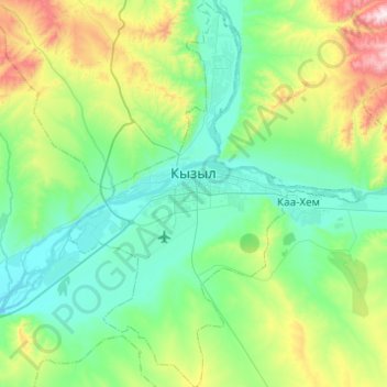
Nome: Mappa topografica Kyzyl, altitudine, rilievo.
Altitudine media: 799 m
Altitudine minima: 600 m
Altitudine massima: 1’547 m
Fai una donazione
Equipaggiati per la tua prossima avventura:
In qualità di Affiliato Amazon, questo sito riceve una commissione sugli acquisti idonei, senza costi aggiuntivi per l’utente.