
Fai una donazione
Equipaggiati per la tua prossima avventura:
In qualità di Affiliato Amazon, questo sito riceve una commissione sugli acquisti idonei, senza costi aggiuntivi per l’utente.
Mappa topografica Decatur
Clicca sulla mappa per visualizzare l'altitudine.
Fai una donazione
Equipaggiati per la tua prossima avventura:
In qualità di Affiliato Amazon, questo sito riceve una commissione sugli acquisti idonei, senza costi aggiuntivi per l’utente.
Decatur
According to the United States Census Bureau, the city has a total area of 8.5 square miles (22 km2), all land. The highest point of elevation in the county is the courthouse site. As with ancient hill towns in Europe, the frontier settlement was developed on high ground for defensive purposes, so European settlers could see and ward off attacks or raids, in this case by Native Americans.
Fai una donazione
Equipaggiati per la tua prossima avventura:
In qualità di Affiliato Amazon, questo sito riceve una commissione sugli acquisti idonei, senza costi aggiuntivi per l’utente.
A proposito di questa mappa
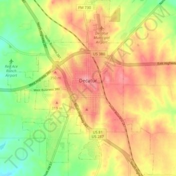
Nome: Mappa topografica Decatur, altitudine, rilievo.
Luogo: Decatur, Wise County, Texas, 76234, United States (33.19772 -97.62301 33.26524 -97.55589)
Altitudine media: 297 m
Altitudine minima: 245 m
Altitudine massima: 340 m
Fai una donazione
Equipaggiati per la tua prossima avventura:
In qualità di Affiliato Amazon, questo sito riceve una commissione sugli acquisti idonei, senza costi aggiuntivi per l’utente.