
Mappa topografica Scofield Reservoir
Mappa interattiva
Clicca sulla mappa per visualizzare l'altitudine.
A proposito di questa mappa
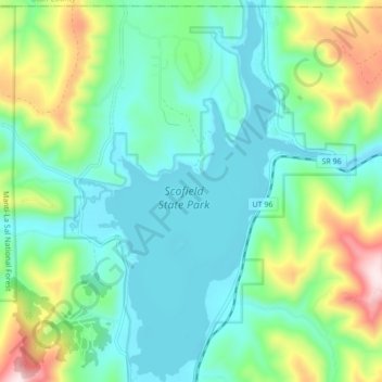
Nome: Mappa topografica Scofield Reservoir, altitudine, rilievo.
Luogo: Scofield Reservoir, Carbon County, Utah, United States (39.74814 -111.17269 39.81400 -111.11997)
Altitudine media: 2’435 m
Altitudine minima: 2’307 m
Altitudine massima: 2’804 m
Scofield Reservoir is a 2,815-acre (11.39 km2) reservoir impounded by Scofield Dam, in Carbon County, Utah. Located on the Price River, a tributary of the Green River, Scofield Reservoir is adjacent to northernmost boundary of the Manti–La Sal National Forest. The reservoir sits at an elevation of 7,618 feet (2,322 m), on the northern edge of the Wasatch Plateau. Utah State Route 96 runs along the western shoreline.
Altre mappe topografiche
Clicca su una mappa per visualizzarne la topografia, l'altitudine e il rilievo.
Carbonville
United States > Utah > Carbon County
Carbonville, Carbon County, Utah, 84591, United States
Altitudine media: 1’741 m
Clear Creek
United States > Utah > Carbon County
Clear Creek, Carbon County, Utah, United States
Altitudine media: 2’726 m
Helper
United States > Utah > Carbon County
Helper, Carbon County, Utah, United States
Altitudine media: 1’912 m
Price
United States > Utah > Carbon County
Price, Carbon County, Utah, 84591, United States
Altitudine media: 1’711 m
Price
United States > Utah > Carbon County > Price > Price
Price, Carbon County, Utah, 84501, United States
Altitudine media: 1’728 m
Scofield
United States > Utah > Carbon County
Scofield, Carbon County, Utah, United States
Altitudine media: 2’499 m