
Fai una donazione
Equipaggiati per la tua prossima avventura:
In qualità di Affiliato Amazon, questo sito riceve una commissione sugli acquisti idonei, senza costi aggiuntivi per l’utente.
Mappa topografica Pachuca
Clicca sulla mappa per visualizzare l'altitudine.
Fai una donazione
Equipaggiati per la tua prossima avventura:
In qualità di Affiliato Amazon, questo sito riceve una commissione sugli acquisti idonei, senza costi aggiuntivi per l’utente.
Pachuca
Pachuca has a semi-arid climate (Köppen climate classification BSk). The climate is cool with high rainfall and occasional hail during the summer months and dry conditions during the winter. The coldest month is January, with an average high of 20 °C (68 °F) and an average low of 3 °C (37 °F). Winter nights are cold and the temperature can drop below 0 °C (32 °F). The warmest month is May, with an average high of 24 °C (75 °F) and a low of 9 °C (48 °F). Due to its high altitude, nighttime temperatures remain cool throughout the year. The average annual precipitation is 412 millimetres (16.2 in), mostly concentrated in the months May through September. In terms of extremes, the record high was 34.5 °C (94 °F) and the record low was −9 °C (16 °F).
Fai una donazione
Equipaggiati per la tua prossima avventura:
In qualità di Affiliato Amazon, questo sito riceve una commissione sugli acquisti idonei, senza costi aggiuntivi per l’utente.
A proposito di questa mappa
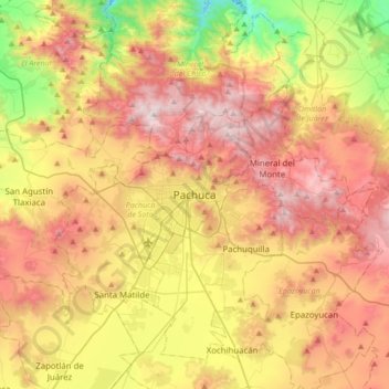
Nome: Mappa topografica Pachuca, altitudine, rilievo.
Luogo: Pachuca, Pachuca de Soto, Hidalgo, 42060, Mexico (19.95654 -98.90135 20.27654 -98.58135)
Altitudine media: 2’459 m
Altitudine minima: 1’794 m
Altitudine massima: 3’105 m
Fai una donazione
Equipaggiati per la tua prossima avventura:
In qualità di Affiliato Amazon, questo sito riceve una commissione sugli acquisti idonei, senza costi aggiuntivi per l’utente.