
Fai una donazione
Equipaggiati per la tua prossima avventura:
In qualità di Affiliato Amazon, questo sito riceve una commissione sugli acquisti idonei, senza costi aggiuntivi per l’utente.
Mappa topografica Linares
Clicca sulla mappa per visualizzare l'altitudine.
Fai una donazione
Equipaggiati per la tua prossima avventura:
In qualità di Affiliato Amazon, questo sito riceve una commissione sugli acquisti idonei, senza costi aggiuntivi per l’utente.
Linares
Most of the territory of the municipality is located within the central plain or "depresión intermedia" (Valle Central de Chile). Some low altitude hills are located in the westernmost part of the municipality, while its easternmost part is marked by the presence of the foothills of the Andes mountains. The municipality of Linares is bordered on the west by San Javier; on the north by Villa Alegre, Yerbas Buenas and Colbún; on the east, by Colbún, and on the south, by Longaví. The municipality of Colbún occupies the easternmost strip of the province, where some of the highest provincial peaks are located, as are the sources of several of the main rivers.
Fai una donazione
Equipaggiati per la tua prossima avventura:
In qualità di Affiliato Amazon, questo sito riceve una commissione sugli acquisti idonei, senza costi aggiuntivi per l’utente.
A proposito di questa mappa
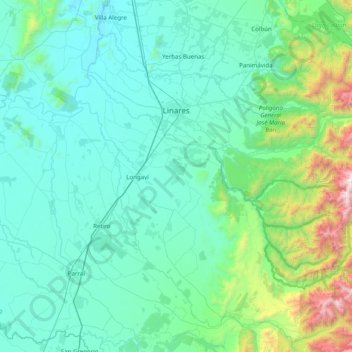
Nome: Mappa topografica Linares, altitudine, rilievo.
Luogo: Linares, Provincia de Linares, Maule Region, Chile (-36.22591 -71.79710 -35.70333 -71.00628)
Altitudine media: 377 m
Altitudine minima: 74 m
Altitudine massima: 2’440 m
Fai una donazione
Equipaggiati per la tua prossima avventura:
In qualità di Affiliato Amazon, questo sito riceve una commissione sugli acquisti idonei, senza costi aggiuntivi per l’utente.
Altre mappe topografiche
Clicca su una mappa per visualizzarne la topografia, l'altitudine e il rilievo.