
Mappa topografica Upington
Mappa interattiva
Clicca sulla mappa per visualizzare l'altitudine.
Upington
The elevation of Upington is 2,742 feet (835 metres). It is the closest large centre to the Augrabies Falls (arguably the greatest of South African waterfalls) and the Kgalagadi Transfrontier Park. The landscape is very arid but the soil is fertile and crops such as fruit are grown in irrigated fields. The area is best known for its export-quality grapes, raisins and wines, which are cultivated on the rich flood plains of the Orange River.
A proposito di questa mappa
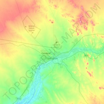
Nome: Mappa topografica Upington, altitudine, rilievo.
Altitudine media: 856 m
Altitudine minima: 769 m
Altitudine massima: 1’006 m