
Fai una donazione
Equipaggiati per la tua prossima avventura:
In qualità di Affiliato Amazon, questo sito riceve una commissione sugli acquisti idonei, senza costi aggiuntivi per l’utente.
Mappa topografica Granger
Clicca sulla mappa per visualizzare l'altitudine.
Fai una donazione
Equipaggiati per la tua prossima avventura:
In qualità di Affiliato Amazon, questo sito riceve una commissione sugli acquisti idonei, senza costi aggiuntivi per l’utente.
A proposito di questa mappa
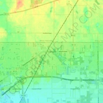
Nome: Mappa topografica Granger, altitudine, rilievo.
Luogo: Granger, Saint Joseph County, Indiana, 46530, United States (41.71338 -86.15084 41.79338 -86.07084)
Altitudine media: 244 m
Altitudine minima: 228 m
Altitudine massima: 266 m
Fai una donazione
Equipaggiati per la tua prossima avventura:
In qualità di Affiliato Amazon, questo sito riceve una commissione sugli acquisti idonei, senza costi aggiuntivi per l’utente.
Altre mappe topografiche
Clicca su una mappa per visualizzarne la topografia, l'altitudine e il rilievo.
South Bend
United States > Indiana > Saint Joseph County
On September 29, 1929, South Bend completed its "track elevation program". This was a railroad infrastructure project which saw the removal of Grand Trunk Western Railroad tracks from Division Street, the removal of level crossings from Chapin to Miami streets, the creation of a modern freight layout, and the…
Altitudine media: 236 m
Fai una donazione
Equipaggiati per la tua prossima avventura:
In qualità di Affiliato Amazon, questo sito riceve una commissione sugli acquisti idonei, senza costi aggiuntivi per l’utente.