
Mappa topografica Navarro County
Clicca sulla mappa per visualizzare l'altitudine.
Navarro County
Navarro County occupies a gently varied part of north-central Texas where broad Blackland Prairie terrain gives way eastward to lower, more dissected creek and reservoir landscapes. The county is described as mostly level to rolling blacklands, with open prairie dominant and woodland areas of oak, hickory, and pine in places, while the Trinity River forms its northeastern boundary. Elevations generally descend from the higher western and southwestern margins toward the lower eastern drainage corridors, with the provided elevation data suggesting a local range from about 250 to 600 ft (76 to 183 m). Around Corsicana and the central county, relief is modest and agricultural plains are cut by shallow valleys, while Richland Creek, Chambers Creek, Navarro Mills Lake, and the large Richland-Chambers Reservoir create broader low-lying basins and gently embayed shorelines; the reservoir’s conservation pool is listed at 315 ft (96 m) above mean sea level. Overall, Navarro County’s topography is not mountainous but softly undulating, with a prairie-and-drainage character shaped by clay-rich uplands, gradual slopes, and the eastward organization of creeks and river bottoms.
A proposito di questa mappa
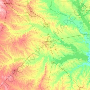
Nome: Mappa topografica Navarro County, altitudine, rilievo.
Luogo: Navarro County, Texas, United States (31.79629 -96.89618 32.32922 -96.05079)
Altitudine media: 131 m
Altitudine minima: 73 m
Altitudine massima: 228 m
Altre mappe topografiche
Clicca su una mappa per visualizzarne la topografia, l'altitudine e il rilievo.
Georgetown
United States > Texas > Georgetown
The city is located on the northeastern edge of Texas Hill Country. Portions of Georgetown are located on either side of the Balcones Escarpment, a fault line in which the areas roughly east of IH-35 are flat and characterized by having black, fertile soils of the Blackland Prairie, and the west side of the…
Altitudine media: 219 m
Lower Rio Grande Valley National Wildlife Refuge
United States > Texas > Starr County > Rio Grande City
Altitudine media: 50 m
Enchanted Rock
United States > Texas > Llano County
Enchanted Rock is a pink granite mountain located in the Llano Uplift about 17 miles (27 km) north of Fredericksburg, Texas and 24 miles (39 km) south of Llano, Texas, United States. Enchanted Rock State Natural Area, which includes Enchanted Rock and surrounding land, spans the border between Gillespie and…
Altitudine media: 453 m
Padre Island National Seashore
United States > Texas > Kenedy County > Corpus Christi
Altitudine media: 5 m
Choke Canyon State Park - Calliham Unit
United States > Texas > McMullen County > Calliham
Altitudine media: 67 m
Mineral Wells Fossil Park
United States > Texas > Palo Pinto County > Mineral Wells
Altitudine media: 283 m