
Mappa topografica Billings
Mappa interattiva
Clicca sulla mappa per visualizzare l'altitudine.
A proposito di questa mappa
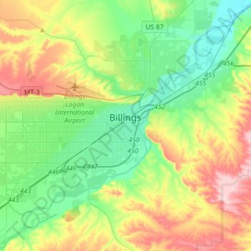
Nome: Mappa topografica Billings, altitudine, rilievo.
Luogo: Billings, Yellowstone County, Montana, United States (45.71067 -108.69152 45.85265 -108.43592)
Altitudine media: 1’023 m
Altitudine minima: 923 m
Altitudine massima: 1’219 m
Two-thirds of the city is in the Yellowstone Valley and the South Hills area and one-third in the Heights-Lockwood area. The city is divided by the Rims, long cliffs, also called the Rimrocks. The Rims run to the north and east of the downtown core, separating it from the Heights to the north and Lockwood to the east, with the cliffs to the north being 500 feet (150 m) tall and to the east of downtown, the face rises 800 feet (240 m). Billings elevation is 3,126 feet above sea level. The Yellowstone River runs through the southeast portion of the city. According to the United States Census Bureau, the city has an area of 43.52 square miles (112.72 km2), of which, 43.41 square miles (112.43 km2) is land and 0.11 square miles (0.28 km2) is water.[49]
Altre mappe topografiche
Clicca su una mappa per visualizzarne la topografia, l'altitudine e il rilievo.
Baseline
United States > Montana > Yellowstone County
Baseline, Yellowstone County, Montana, 59103, United States
Altitudine media: 1’043 m
Lake Elmo
United States > Montana > Yellowstone County > Billings
Lake Elmo, Billings, Yellowstone County, Montana, United States
Altitudine media: 974 m