
Fai una donazione
Equipaggiati per la tua prossima avventura:
In qualità di Affiliato Amazon, questo sito riceve una commissione sugli acquisti idonei, senza costi aggiuntivi per l’utente.
Mappa topografica Colachel
Clicca sulla mappa per visualizzare l'altitudine.
Fai una donazione
Equipaggiati per la tua prossima avventura:
In qualità di Affiliato Amazon, questo sito riceve una commissione sugli acquisti idonei, senza costi aggiuntivi per l’utente.
Colachel
The town is located on the western coastal side of Kanyakumari District and falls in the coordinates of 8°09′N 77°08′E / 8.15°N 77.14°E / 8.15; 77.14. The average elevation of the town is 25 meters (82 ft) above Mean Sea Level (MSL). Town is mostly characterized by a flat terrain with a few areas in the northwest region having elevation difference with other parts of the town. Generally the town is sloped gently from North to south direction and also sloping in a radial direction towards centre portion of the town from east and west directions.
Fai una donazione
Equipaggiati per la tua prossima avventura:
In qualità di Affiliato Amazon, questo sito riceve una commissione sugli acquisti idonei, senza costi aggiuntivi per l’utente.
A proposito di questa mappa
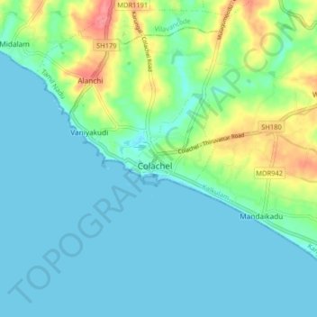
Nome: Mappa topografica Colachel, altitudine, rilievo.
Luogo: Colachel, Kalkulam, Kanniyakumari, Tamil Nadu, 629251, India (8.13527 77.21192 8.21527 77.29192)
Altitudine media: 16 m
Altitudine minima: -1 m
Altitudine massima: 72 m
Fai una donazione
Equipaggiati per la tua prossima avventura:
In qualità di Affiliato Amazon, questo sito riceve una commissione sugli acquisti idonei, senza costi aggiuntivi per l’utente.