
Fai una donazione
Equipaggiati per la tua prossima avventura:
In qualità di Affiliato Amazon, questo sito riceve una commissione sugli acquisti idonei, senza costi aggiuntivi per l’utente.
Mappa topografica Saint Petersburg
Clicca sulla mappa per visualizzare l'altitudine.
Fai una donazione
Equipaggiati per la tua prossima avventura:
In qualità di Affiliato Amazon, questo sito riceve una commissione sugli acquisti idonei, senza costi aggiuntivi per l’utente.
Saint Petersburg
The elevation of Saint Petersburg ranges from the sea level to its highest point of 175.9 m (577 ft) at the Orekhovaya Hill in the Duderhof Heights in the south. Part of the city's territory west of Liteyny Prospekt is no higher than 4 m (13 ft) above sea level, and has suffered from numerous floods. Floods in Saint Petersburg are triggered by a long wave in the Baltic Sea, caused by meteorological conditions, winds and shallowness of the Neva Bay. The five most disastrous floods occurred in 1824 (4.21 m or 13 ft 10 in above sea level, during which over 300 buildings were destroyed); 1924 (3.8 m, 12 ft 6 in); 1777 (3.21 m, 10 ft 6 in); 1955 (2.93 m, 9 ft 7 in); and 1975 (2.81 m, 9 ft 3 in). To prevent floods, the Saint Petersburg Dam has been constructed.
Fai una donazione
Equipaggiati per la tua prossima avventura:
In qualità di Affiliato Amazon, questo sito riceve una commissione sugli acquisti idonei, senza costi aggiuntivi per l’utente.
A proposito di questa mappa
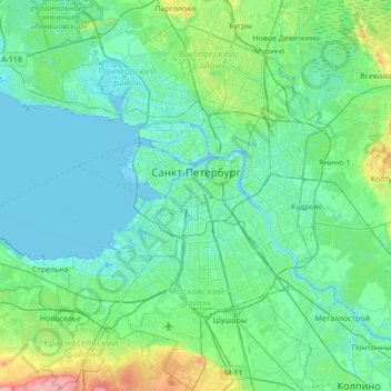
Nome: Mappa topografica Saint Petersburg, altitudine, rilievo.
Luogo: Saint Petersburg, Northwestern Federal District, Russia (59.74415 30.04334 60.09074 30.56717)
Altitudine media: 17 m
Altitudine minima: -3 m
Altitudine massima: 118 m
Fai una donazione
Equipaggiati per la tua prossima avventura:
In qualità di Affiliato Amazon, questo sito riceve una commissione sugli acquisti idonei, senza costi aggiuntivi per l’utente.
Altre mappe topografiche
Clicca su una mappa per visualizzarne la topografia, l'altitudine e il rilievo.
Saint Petersburg
Russia > Saint Petersburg > Saint Petersburg
The elevation of Saint Petersburg ranges from the sea level to its highest point of 175.9 m (577 ft) at the Orekhovaya Hill in the Duderhof Heights in the south. Part of the city's territory west of Liteyny Prospekt is no higher than 4 m (13 ft) above sea level, and has suffered from numerous floods. Floods in…
Altitudine media: 14 m