
Mappa topografica Bakersfield
Mappa interattiva
Clicca sulla mappa per visualizzare l'altitudine.
A proposito di questa mappa
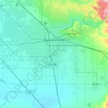
Nome: Mappa topografica Bakersfield, altitudine, rilievo.
Luogo: Bakersfield, Kern County, California, United States (35.19398 -119.26503 35.44730 -118.77234)
Altitudine media: 157 m
Altitudine minima: 81 m
Altitudine massima: 915 m
Most of Bakersfield's major streets are six-lane divided roads with bike lanes, with almost every street in the city having proper lane signage for bicycle traffic. Bikes are a popular method of transportation in Bakersfield, due to the city's relatively flat topography and grid-like street system. Newer neighborhoods on the outskirts of the city, previously surrounded by two-lane farm roads, are prompting more large, divided roads to be built to help ease the increase in traffic that has resulted from an explosion in population. Many developers choose to widen the roads that connect these neighborhoods at their own discretion, which can cause a major road to widen and narrow repeatedly over a short distance (Allen Road and Panama Lane are prime examples of this). Since the Bakersfield city limit boundaries are not uniform and leap over different neighborhoods, this can cause Kern County "islands" to exist within Bakersfield. The county of Kern may choose not to upgrade a road while the city of Bakersfield does improve a road, which can cause traffic congestion to increase (Calloway Drive from the Westside Parkway north to Rosedale Highway best exemplifies this disparity).
Altre mappe topografiche
Clicca su una mappa per visualizzarne la topografia, l'altitudine e il rilievo.
Rosedale
United States > California > Kern County
Rosedale, Kern County, California, United States
Altitudine media: 113 m
Upper Richbar Picnic Area
United States > California > Kern County
Upper Richbar Picnic Area, Kern County, California, United States
Altitudine media: 658 m
Wasco
United States > California > Kern County
Wasco, Kern County, California, United States
Altitudine media: 101 m
Mojave
United States > California > Kern County
Mojave, Kern County, California, United States
Altitudine media: 857 m
Inyokern
United States > California > Kern County
Inyokern, Kern County, California, United States
Altitudine media: 749 m
Baker
United States > California > Kern County > Boron
Baker, Boron, Kern County, California, United States
Altitudine media: 765 m
Rosedale
United States > California > Kern County
Rosedale, Kern County, CAL Fire Contract Counties, California, United States
Altitudine media: 107 m
Ridgecrest
United States > California > Kern County
Ridgecrest, Kern County, California, 93555, United States
Altitudine media: 740 m
Lake Isabella
United States > California > Kern County
Lake Isabella, Kern County, California, United States
Altitudine media: 979 m
Boron
United States > California > Kern County > Boron
Boron, Kern County, California, United States
Altitudine media: 753 m
Tehachapi
United States > California > Kern County
Tehachapi, Kern County, California, 93561, United States
Altitudine media: 1’414 m
Cameron
United States > California > Kern County
Cameron, Kern County, California, United States
Altitudine media: 1’309 m
Rio Bravo
United States > California > Kern County
Rio Bravo, Kern County, California, United States
Altitudine media: 97 m