
Mappa topografica Fitzroy Island
Clicca sulla mappa per visualizzare l'altitudine.
A proposito di questa mappa
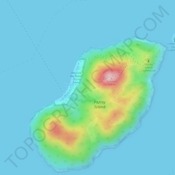
Nome: Mappa topografica Fitzroy Island, altitudine, rilievo.
Luogo: Fitzroy Island, Cairns, Queensland, Australia (-16.94028 145.98223 -16.92028 146.00223)
Altitudine media: 34 m
Altitudine minima: -1 m
Altitudine massima: 235 m
Altre mappe topografiche
Clicca su una mappa per visualizzarne la topografia, l'altitudine e il rilievo.
Kanimbla
Australia > Queensland > Cairns
The suburb straddles the upper reaches of Moody's Creek and is bordered to the north by the Cairns Western Arterial Road (state route 91). The main road that goes through Kanimbla is Ramsey Drive. Along the middle of the northern boundary is Whites Gap. In the south west elevations reach heights greater than…
Altitudine media: 121 m