
Fai una donazione
Equipaggiati per la tua prossima avventura:
In qualità di Affiliato Amazon, questo sito riceve una commissione sugli acquisti idonei, senza costi aggiuntivi per l’utente.
Mappa topografica Islamabad
Clicca sulla mappa per visualizzare l'altitudine.
Fai una donazione
Equipaggiati per la tua prossima avventura:
In qualità di Affiliato Amazon, questo sito riceve una commissione sugli acquisti idonei, senza costi aggiuntivi per l’utente.
Islamabad
Islamabad's micro-climate is regulated by three artificial reservoirs: Rawal, Simli, and Khanpur Dam. The latter is located on the Haro River near the town of Khanpur, about 40 kilometres (25 mi) from Islamabad. Simli Dam is 30 kilometres (19 mi) north of Islamabad. 220 acres (89 ha) of the city consists of Margalla Hills National Park. Loi Bher Forest is situated along the Islamabad Highway, covering an area of 1,087 acres (440 ha). The highest monthly rainfall of 743.3 mm (29.26 in) was recorded during July 1995. Winters generally feature dense fog in the mornings and sunny afternoons. In the city, temperatures stay mild, with snowfall over the higher-elevation points on nearby hill stations, notably Murree and Nathia Gali. The temperatures range from 13 °C (55 °F) in January to 38 °C (100 °F) in June. The highest recorded temperature was 46.6 °C (115.9 °F) on 23 June 2005 while the lowest temperature was −6.0 °C (21.2 °F) on 17 January 1967. Light snowfall sometimes happens on the peaks of the hills visible from the city, though this is rare. Snowfall does not occur in the city itself. On 23 July 2001, Islamabad received a record-breaking 620 mm (24 in) of rainfall in just 10 hours. It was the heaviest rainfall in Islamabad in the past 100 years and the highest rainfall in 24 hours as well. Water supply is strained, leading to project proposals like the Ghazi Barotha water supply project.
Fai una donazione
Equipaggiati per la tua prossima avventura:
In qualità di Affiliato Amazon, questo sito riceve una commissione sugli acquisti idonei, senza costi aggiuntivi per l’utente.
A proposito di questa mappa
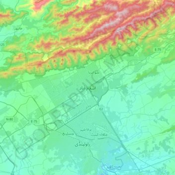
Nome: Mappa topografica Islamabad, altitudine, rilievo.
Altitudine media: 666 m
Altitudine minima: 417 m
Altitudine massima: 1’584 m
Fai una donazione
Equipaggiati per la tua prossima avventura:
In qualità di Affiliato Amazon, questo sito riceve una commissione sugli acquisti idonei, senza costi aggiuntivi per l’utente.
Altre mappe topografiche
Clicca su una mappa per visualizzarne la topografia, l'altitudine e il rilievo.
Fai una donazione
Equipaggiati per la tua prossima avventura:
In qualità di Affiliato Amazon, questo sito riceve una commissione sugli acquisti idonei, senza costi aggiuntivi per l’utente.
Fai una donazione
Equipaggiati per la tua prossima avventura:
In qualità di Affiliato Amazon, questo sito riceve una commissione sugli acquisti idonei, senza costi aggiuntivi per l’utente.