
Fai una donazione
Equipaggiati per la tua prossima avventura:
In qualità di Affiliato Amazon, questo sito riceve una commissione sugli acquisti idonei, senza costi aggiuntivi per l’utente.
Mappa topografica Ural Mountains
Clicca sulla mappa per visualizzare l'altitudine.
Fai una donazione
Equipaggiati per la tua prossima avventura:
In qualità di Affiliato Amazon, questo sito riceve una commissione sugli acquisti idonei, senza costi aggiuntivi per l’utente.
Ural Mountains
The Ural Mountains (/ˈjʊərəl/ YOOR-əl), or simply the Urals, are a mountain range in Eurasia that runs north–south mostly through Russia, from the coast of the Arctic Ocean to the river Ural and northwestern Kazakhstan. The mountain range forms part of the conventional boundary between the continents of Europe and Asia, marking the separation between European Russia and Siberia. Vaygach Island and the islands of Novaya Zemlya form continuations of the chain to the north into the Arctic Ocean. The average altitudes of the Urals are around 1,000–1,300 metres (3,300–4,300 ft), the highest point being Mount Narodnaya, which reaches a height of 1,894 metres (6,214 ft).
Fai una donazione
Equipaggiati per la tua prossima avventura:
In qualità di Affiliato Amazon, questo sito riceve una commissione sugli acquisti idonei, senza costi aggiuntivi per l’utente.
A proposito di questa mappa
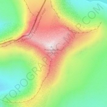
Nome: Mappa topografica Ural Mountains, altitudine, rilievo.
Altitudine media: 1’435 m
Altitudine minima: 1’101 m
Altitudine massima: 1’893 m
Fai una donazione
Equipaggiati per la tua prossima avventura:
In qualità di Affiliato Amazon, questo sito riceve una commissione sugli acquisti idonei, senza costi aggiuntivi per l’utente.
Altre mappe topografiche
Clicca su una mappa per visualizzarne la topografia, l'altitudine e il rilievo.
Шайтанка
Russia > Khanty-Mansiysk Autonomous Okrug – Ugra > Beryozovsky District > Beryozovo
Altitudine media: 24 m
Хурумпауль
Russia > Khanty-Mansiysk Autonomous Okrug – Ugra > Beryozovsky District
Altitudine media: 21 m