
Fai una donazione
Equipaggiati per la tua prossima avventura:
In qualità di Affiliato Amazon, questo sito riceve una commissione sugli acquisti idonei, senza costi aggiuntivi per l’utente.
Mappa topografica Crystal Lake
Clicca sulla mappa per visualizzare l'altitudine.
Fai una donazione
Equipaggiati per la tua prossima avventura:
In qualità di Affiliato Amazon, questo sito riceve una commissione sugli acquisti idonei, senza costi aggiuntivi per l’utente.
Crystal Lake
The CDP is home to Crystal Lake, a 187-acre (76 ha) lake that straddles the border between Ellington and Stafford. Most of the lake shore is occupied by private residences, but there is a small public beach called Sandy Beach on the south side of the lake. The lake has an average depth of 20 feet (6.1 m), a maximum depth of 50 feet (15 m) and an elevation of 637 feet (194 m).
Fai una donazione
Equipaggiati per la tua prossima avventura:
In qualità di Affiliato Amazon, questo sito riceve una commissione sugli acquisti idonei, senza costi aggiuntivi per l’utente.
A proposito di questa mappa
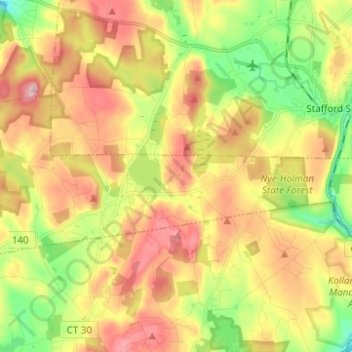
Nome: Mappa topografica Crystal Lake, altitudine, rilievo.
Altitudine media: 213 m
Altitudine minima: 113 m
Altitudine massima: 315 m
Fai una donazione
Equipaggiati per la tua prossima avventura:
In qualità di Affiliato Amazon, questo sito riceve una commissione sugli acquisti idonei, senza costi aggiuntivi per l’utente.