
Fai una donazione
Equipaggiati per la tua prossima avventura:
In qualità di Affiliato Amazon, questo sito riceve una commissione sugli acquisti idonei, senza costi aggiuntivi per l’utente.
Mappa topografica Coaldale
Clicca sulla mappa per visualizzare l'altitudine.
Fai una donazione
Equipaggiati per la tua prossima avventura:
In qualità di Affiliato Amazon, questo sito riceve una commissione sugli acquisti idonei, senza costi aggiuntivi per l’utente.
Coaldale
Coaldale is located at 40°49′20″N 75°54′36″W / 40.82222°N 75.91000°W / 40.82222; -75.91000 (40.822234, -75.910115), which is (technically) one mile southwest of Lansford as both municipalities lie along the border of Carbon and Schuylkill Counties. It is also five miles northeast of Tamaqua, 27 miles northwest of Allentown, and nine miles south of Hazleton. It is located on the northwestern fringe of the Lehigh Valley and just two ridgelines away from the nearby Poconos, and drains to the Delaware River by way of Panther Creek, the Little Schuylkill River, and the Schuylkill River. Coaldale sits atop one of the richest coal seams in the eastern end of the southern Coal Region, which is still being exploited by a successor company of the LC&N (called the Old Company in the valley), the Lehigh Coal and Navigation Company (or the New Company). Coaldale's elevation is 1050 feet above sea level. According to the United States Census Bureau, the borough has a total area of 2.2 square miles (5.7 km2), all land.
Fai una donazione
Equipaggiati per la tua prossima avventura:
In qualità di Affiliato Amazon, questo sito riceve una commissione sugli acquisti idonei, senza costi aggiuntivi per l’utente.
A proposito di questa mappa
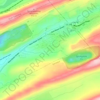
Nome: Mappa topografica Coaldale, altitudine, rilievo.
Luogo: Coaldale, Schuylkill County, Pennsylvania, United States (40.80509 -75.93646 40.83388 -75.89158)
Altitudine media: 360 m
Altitudine minima: 252 m
Altitudine massima: 481 m
Fai una donazione
Equipaggiati per la tua prossima avventura:
In qualità di Affiliato Amazon, questo sito riceve una commissione sugli acquisti idonei, senza costi aggiuntivi per l’utente.
Altre mappe topografiche
Clicca su una mappa per visualizzarne la topografia, l'altitudine e il rilievo.
Park Place
United States > Pennsylvania > Schuylkill County > Mahanoy Township
Altitudine media: 515 m
Fai una donazione
Equipaggiati per la tua prossima avventura:
In qualità di Affiliato Amazon, questo sito riceve una commissione sugli acquisti idonei, senza costi aggiuntivi per l’utente.
Blue Mountain
United States > Pennsylvania > Schuylkill County > Washington Township
The ridge of Blue Mountain runs for 150 miles (240 km) through Pennsylvania, reaching an elevation of 2,270 feet (690 m) above sea level just north of the Pennsylvania Turnpike, near the borough of Newburg. Most of the ridgecrest, however, only reaches between 1,400 and 1,700 feet (430 and 520 m) in elevation.…
Altitudine media: 226 m
Nuremberg
United States > Pennsylvania > Schuylkill County > North Union Township
Altitudine media: 377 m