
Fai una donazione
Equipaggiati per la tua prossima avventura:
In qualità di Affiliato Amazon, questo sito riceve una commissione sugli acquisti idonei, senza costi aggiuntivi per l’utente.
Mappa topografica Juniper
Clicca sulla mappa per visualizzare l'altitudine.
Fai una donazione
Equipaggiati per la tua prossima avventura:
In qualità di Affiliato Amazon, questo sito riceve una commissione sugli acquisti idonei, senza costi aggiuntivi per l’utente.
A proposito di questa mappa
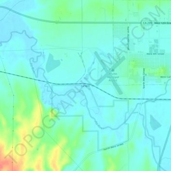
Nome: Mappa topografica Juniper, altitudine, rilievo.
Luogo: Juniper, Modoc County, California, 96101, United States (41.45989 -120.59273 41.49989 -120.55273)
Altitudine media: 1’337 m
Altitudine minima: 1’324 m
Altitudine massima: 1’387 m
Fai una donazione
Equipaggiati per la tua prossima avventura:
In qualità di Affiliato Amazon, questo sito riceve una commissione sugli acquisti idonei, senza costi aggiuntivi per l’utente.
Altre mappe topografiche
Clicca su una mappa per visualizzarne la topografia, l'altitudine e il rilievo.
Alturas
United States > California > Modoc County
Alturas (Spanish for "Heights"; Achumawi: Kasalektawi) is a city and the county seat of Modoc County, California. Located in the Shasta Cascade region of Northern California, the city had a population of 2,715 at the 2020 census. Alturas is located at the confluence of the south and north forks of the Pit…
Altitudine media: 1’336 m
Lake City
United States > California > Modoc County
Lake City (formerly, Tri-Lake City) is a census-designated place in Modoc County, California, United States. It is located 8.5 miles (14 km) north-northwest of Cedarville, at an elevation of 4,626 feet (1,410 m). Its population is 71 as of the 2020 census, up from 61 from the 2010 census.
Altitudine media: 1’583 m
Alturas
United States > California > Modoc County
Alturas (Spanish for "Heights"; Achumawi: Kasalektawi) is a city and the county seat of Modoc County, California. Located in the Shasta Cascade region of Northern California, the city had a population of 2,715 at the 2020 census. Alturas is located at the confluence of the south and north forks of the Pit…
Altitudine media: 1’337 m
Fai una donazione
Equipaggiati per la tua prossima avventura:
In qualità di Affiliato Amazon, questo sito riceve una commissione sugli acquisti idonei, senza costi aggiuntivi per l’utente.
Alturas
United States > California > Modoc County
Alturas (Spanish for "Heights"; Achumawi: Kasalektawi) is the only incorporated city in Modoc County, California of which it is also the county seat. Located in the Shasta Cascade region of Northern California, the city had a population of 2,715 at the 2020 census. Alturas is located at the confluence of the…
Altitudine media: 1’337 m