
Fai una donazione
Equipaggiati per la tua prossima avventura:
In qualità di Affiliato Amazon, questo sito riceve una commissione sugli acquisti idonei, senza costi aggiuntivi per l’utente.
Mappa topografica Shaniko
Clicca sulla mappa per visualizzare l'altitudine.
Fai una donazione
Equipaggiati per la tua prossima avventura:
In qualità di Affiliato Amazon, questo sito riceve una commissione sugli acquisti idonei, senza costi aggiuntivi per l’utente.
Shaniko
The city is at an elevation of 3,343 feet (1,019 m). On the high plateau on which Shaniko was built, the soil is thin and the vegetation sparse, consisting mainly of sagebrush, bunchgrass, and occasional junipers. Many peaks of the Cascade Range, including Hood, Jefferson, Adams, St. Helens and Rainier, are visible from the city.
Fai una donazione
Equipaggiati per la tua prossima avventura:
In qualità di Affiliato Amazon, questo sito riceve una commissione sugli acquisti idonei, senza costi aggiuntivi per l’utente.
A proposito di questa mappa
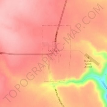
Nome: Mappa topografica Shaniko, altitudine, rilievo.
Luogo: Shaniko, Wasco County, Oregon, United States (44.99660 -120.75733 45.01082 -120.74709)
Altitudine media: 1’009 m
Altitudine minima: 900 m
Altitudine massima: 1’038 m
Fai una donazione
Equipaggiati per la tua prossima avventura:
In qualità di Affiliato Amazon, questo sito riceve una commissione sugli acquisti idonei, senza costi aggiuntivi per l’utente.