
Mappa topografica Horley
Clicca sulla mappa per visualizzare l'altitudine.
Horley
Horley is at an altitude of around 54 m (177 ft) above mean sea level.
A proposito di questa mappa
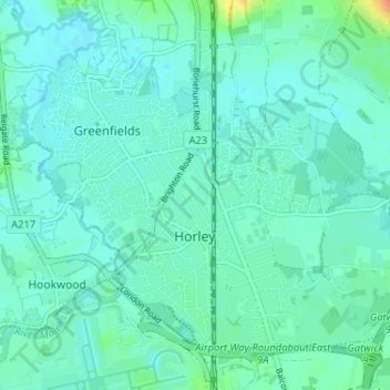
Nome: Mappa topografica Horley, altitudine, rilievo.
Luogo: Horley, Reigate and Banstead, Surrey, England, United Kingdom (51.15959 -0.19230 51.19230 -0.12775)
Altitudine media: 58 m
Altitudine minima: 50 m
Altitudine massima: 91 m
Altre mappe topografiche
Clicca su una mappa per visualizzarne la topografia, l'altitudine e il rilievo.
Redhill
United Kingdom > England > Surrey > Reigate and Banstead
To the north, the town joins with the village of Merstham, north of which there is a "wind gap" in the chalk hills of the North Downs, at an elevation of 120 metres (390 ft) above sea level, through which the A23 road heads in from London. Geologists have speculated that there may once have been a…
Altitudine media: 107 m
Reigate
United Kingdom > England > Surrey > Reigate and Banstead
Reigate is in central Surrey, around 19 mi (30 km) south of central London and 9 mi (14 km) north of Gatwick Airport. The town is in the Vale of Holmesdale, below the North Downs escarpment. The average elevation in the centre is 80 m (260 ft) above ordnance datum (OD) and the area is drained by the Wallace…
Altitudine media: 100 m
Gatton
United Kingdom > England > Surrey > Reigate and Banstead
Gatton's elevations range from 215m AOD, the highest elevation, along Fort Lane, a cul-de-sac off the intersection of Reigate Hill (M25 Junction 8) which leads to four homes over the boundary in Reigate, a radio transmitter station, and a water tower. On the A217 is the Bridge House Hotel, whose name refers to…
Altitudine media: 134 m
Margery
United Kingdom > England > Surrey > Reigate and Banstead > Lower Kingswood
Altitudine media: 155 m
Lower Earlswood Lake
United Kingdom > England > Surrey > Reigate and Banstead > Redhill
Altitudine media: 75 m
Redhill Common
United Kingdom > England > Surrey > Reigate and Banstead > Redhill
Altitudine media: 92 m
Buckland Corner
United Kingdom > England > Surrey > Reigate and Banstead > Reigate
Altitudine media: 82 m
Norwood Hill
United Kingdom > England > Surrey > Reigate and Banstead > Norwood Hill
Altitudine media: 71 m
Redhill
United Kingdom > England > Surrey > Reigate and Banstead
To the north, the town joins with the village of Merstham, north of which there is a "wind gap" in the chalk hills of the North Downs, at an elevation of 120 metres (390 feet) above sea level, through which the A23 road heads in from London. Geologists have speculated that there may once have been a…
Altitudine media: 107 m
Reigate
United Kingdom > England > Surrey > Reigate and Banstead
Reigate is in central Surrey, around 19 mi (30 km) south of central London and 9 mi (14 km) north of Gatwick Airport. The town is in the Vale of Holmesdale, below the North Downs escarpment. The average elevation in the centre is 80 m (260 ft) above ordnance datum (OD) and the area is drained by the Wallace…
Altitudine media: 100 m
Margery
United Kingdom > England > Surrey > Reigate and Banstead > Lower Kingswood
Altitudine media: 155 m
Redhill
United Kingdom > England > Surrey > Reigate and Banstead
To the north, the town joins with the village of Merstham, north of which there is a "wind gap" in the chalk hills of the North Downs, at an elevation of 120 metres (390 feet) above sea level, through which the A23 road heads in from London. Geologists have speculated that there may once have been a…
Altitudine media: 107 m