
Mappa topografica Tombstone
Mappa interattiva
Clicca sulla mappa per visualizzare l'altitudine.
A proposito di questa mappa
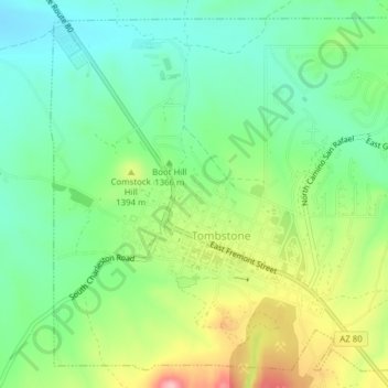
Nome: Mappa topografica Tombstone, altitudine, rilievo.
Luogo: Tombstone, Cochise County, Arizona, 85638, United States (31.70272 -110.08222 31.73268 -110.04366)
Altitudine media: 1’362 m
Altitudine minima: 1’304 m
Altitudine massima: 1’468 m
The Tombstone District located at 31°42′57″N 110°3′53″W / 31.71583°N 110.06472°W / 31.71583; -110.06472 (31.715940, −110.064827) sits atop a mesa (elevation 4,539 feet (1,383 m)) in the San Pedro River valley between the Huachuca Mountains and Whetstone Mountains to the west, and the Mules and the Dragoon Mountains to the east. According to the United States Census Bureau, the city has a total area of 4.3 square miles (11.2 km2), all land.