
Mappa topografica 2388
Mappa interattiva
Clicca sulla mappa per visualizzare l'altitudine.
2388
In addition to Mount Mitchell itself, the park encompasses several other peaks which top out at over 6,000 feet (1,800 m) in elevation, including Mount Hallback, Mount Craig (just 52 feet (16 m) shy of Mount Mitchell in elevation and the second highest peak east of the Mississippi River), Big Tom and Balsam Cone. Trails lead to all these summits save Mount Hallback, and their exploration takes visitors away from the crowds on Mount Mitchell but to places similarly spectacular. About 8 miles (13 km) of trails exist within the park in all.
A proposito di questa mappa
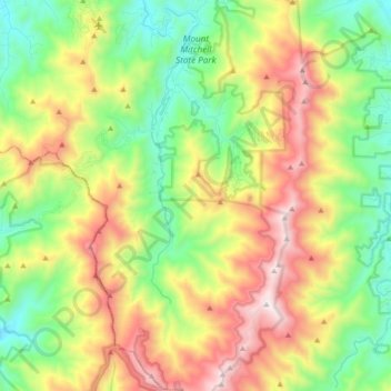
Nome: Mappa topografica 2388, altitudine, rilievo.
Altitudine media: 1’274 m
Altitudine minima: 786 m
Altitudine massima: 2’019 m