
Fai una donazione
Equipaggiati per la tua prossima avventura:
In qualità di Affiliato Amazon, questo sito riceve una commissione sugli acquisti idonei, senza costi aggiuntivi per l’utente.
Mappa topografica Manorville
Clicca sulla mappa per visualizzare l'altitudine.
Fai una donazione
Equipaggiati per la tua prossima avventura:
In qualità di Affiliato Amazon, questo sito riceve una commissione sugli acquisti idonei, senza costi aggiuntivi per l’utente.
Manorville
Manorville is in the center of Long Island with no access to the water. It lies partially on the Ronkonkoma terminal moraine, which creates some slightly rolling topography, especially in the central portion of the hamlet. The glacial topography of the area features several kettle hole ponds, the most well-known of which is Punk's Hole, where a Revolutionary War captain was rumored to have hid from the British.
Fai una donazione
Equipaggiati per la tua prossima avventura:
In qualità di Affiliato Amazon, questo sito riceve una commissione sugli acquisti idonei, senza costi aggiuntivi per l’utente.
A proposito di questa mappa
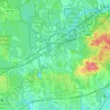
Nome: Mappa topografica Manorville, altitudine, rilievo.
Altitudine media: 22 m
Altitudine minima: 4 m
Altitudine massima: 80 m
Fai una donazione
Equipaggiati per la tua prossima avventura:
In qualità di Affiliato Amazon, questo sito riceve una commissione sugli acquisti idonei, senza costi aggiuntivi per l’utente.
Altre mappe topografiche
Clicca su una mappa per visualizzarne la topografia, l'altitudine e il rilievo.
Eastport South Manor Athletic Complex
United States > New York > Suffolk County > Town of Brookhaven > Eastport
Altitudine media: 15 m