
Fai una donazione
Equipaggiati per la tua prossima avventura:
In qualità di Affiliato Amazon, questo sito riceve una commissione sugli acquisti idonei, senza costi aggiuntivi per l’utente.
Mappa topografica Villaflores
Clicca sulla mappa per visualizzare l'altitudine.
Fai una donazione
Equipaggiati per la tua prossima avventura:
In qualità di Affiliato Amazon, questo sito riceve una commissione sugli acquisti idonei, senza costi aggiuntivi per l’utente.
Villaflores
Villaflores is a municipality in the southern Mexican state of Chiapas, and the name of its largest settlement and seat of the municipal government. Situated in the Sierra Madre de Chiapas range, the municipality has an area of approximately 1232 km2 at an average elevation of 540m above mean sea level.
Fai una donazione
Equipaggiati per la tua prossima avventura:
In qualità di Affiliato Amazon, questo sito riceve una commissione sugli acquisti idonei, senza costi aggiuntivi per l’utente.
A proposito di questa mappa
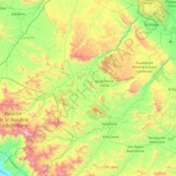
Nome: Mappa topografica Villaflores, altitudine, rilievo.
Luogo: Villaflores, Chiapas, 30475, Mexico (16.16423 -93.77099 16.58582 -93.04802)
Altitudine media: 820 m
Altitudine minima: 34 m
Altitudine massima: 2’430 m
Fai una donazione
Equipaggiati per la tua prossima avventura:
In qualità di Affiliato Amazon, questo sito riceve una commissione sugli acquisti idonei, senza costi aggiuntivi per l’utente.
Altre mappe topografiche
Clicca su una mappa per visualizzarne la topografia, l'altitudine e il rilievo.
Tuxtla Gutiérrez
Mexico > Chiapas > Tuxtla Gutiérrez
On the edge of the city is the El Zapotal Ecological Reserve, best known as the home of the Zoológico Miguel Alvarez del Toro Zoo, often referred to as the ZooMAT. The zoo covers 100 hectares and was founded by Miguel Alvarez del Toro in 1942. He was also the director for over fifty years. ZooMAT is…
Altitudine media: 817 m
San Cristóbal
Mexico > Chiapas > San Cristóbal de las Casas
The city and municipality are located in a region called the Chiapas Highlands or Central Highlands. Two thirds of the municipality is made up of mountainous terrain with the rest valley floor. The city proper is located at 2,200 meters above sea level in a small valley surrounded by hills. The most important…
Altitudine media: 2’038 m
Fai una donazione
Equipaggiati per la tua prossima avventura:
In qualità di Affiliato Amazon, questo sito riceve una commissione sugli acquisti idonei, senza costi aggiuntivi per l’utente.
Fai una donazione
Equipaggiati per la tua prossima avventura:
In qualità di Affiliato Amazon, questo sito riceve una commissione sugli acquisti idonei, senza costi aggiuntivi per l’utente.
San Cristóbal
Mexico > Chiapas > San Cristóbal de las Casas
The city and municipality are located in a region called the Chiapas Highlands or Central Highlands. Two thirds of the municipality is made up of mountainous terrain with the rest valley floor. The city proper is located at 2,200 meters above sea level in a small valley surrounded by hills. The most important…
Altitudine media: 2’038 m
Tapachula
The cuisine of the municipality varies greatly as the topography extends from the ocean into the mountains. Main annual events include Chinese New Year, San Benito, the Feria Tapachula, San Agustín, Jesús de la Buena Esperanza and San Miguel.
Altitudine media: 202 m
Fai una donazione
Equipaggiati per la tua prossima avventura:
In qualità di Affiliato Amazon, questo sito riceve una commissione sugli acquisti idonei, senza costi aggiuntivi per l’utente.
San Cristóbal
Mexico > Chiapas > San Cristóbal de las Casas
The city and municipality are located in a region called the Chiapas Highlands or Central Highlands. Two thirds of the municipality is made up of mountainous terrain with the rest valley floor. The city proper is located at 2,200 meters above sea level in a small valley surrounded by hills. The most important…
Altitudine media: 2’038 m
Fai una donazione
Equipaggiati per la tua prossima avventura:
In qualità di Affiliato Amazon, questo sito riceve una commissione sugli acquisti idonei, senza costi aggiuntivi per l’utente.
Fai una donazione
Equipaggiati per la tua prossima avventura:
In qualità di Affiliato Amazon, questo sito riceve una commissione sugli acquisti idonei, senza costi aggiuntivi per l’utente.
Reserva de la Biósfera Selva El Ocote
Mexico > Chiapas > Ocozocoautla de Espinosa
Altitudine media: 609 m
Fai una donazione
Equipaggiati per la tua prossima avventura:
In qualità di Affiliato Amazon, questo sito riceve una commissione sugli acquisti idonei, senza costi aggiuntivi per l’utente.