
Fai una donazione
Equipaggiati per la tua prossima avventura:
In qualità di Affiliato Amazon, questo sito riceve una commissione sugli acquisti idonei, senza costi aggiuntivi per l’utente.
Mappa topografica Walden
Clicca sulla mappa per visualizzare l'altitudine.
Fai una donazione
Equipaggiati per la tua prossima avventura:
In qualità di Affiliato Amazon, questo sito riceve una commissione sugli acquisti idonei, senza costi aggiuntivi per l’utente.
Walden
Walden is the Statutory Town that is the county seat, the most populous community, and the only incorporated municipality in Jackson County, Colorado, United States. It is situated in the center of a large open valley called North Park. People from Walden and the surrounding area refer to themselves as "North Parkers". The town population was 606 at the 2020 census. The town sits at an elevation of 8,099 feet (2,469 meters). It was established in 1889 and was incorporated 2 December 1890. Mark A. Walden, an early postmaster, gave the community his name.
Fai una donazione
Equipaggiati per la tua prossima avventura:
In qualità di Affiliato Amazon, questo sito riceve una commissione sugli acquisti idonei, senza costi aggiuntivi per l’utente.
A proposito di questa mappa
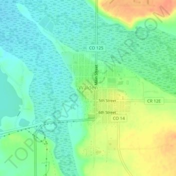
Nome: Mappa topografica Walden, altitudine, rilievo.
Luogo: Walden, Jackson County, Colorado, United States (40.72605 -106.28693 40.73695 -106.27409)
Altitudine media: 2’463 m
Altitudine minima: 2’447 m
Altitudine massima: 2’490 m
Fai una donazione
Equipaggiati per la tua prossima avventura:
In qualità di Affiliato Amazon, questo sito riceve una commissione sugli acquisti idonei, senza costi aggiuntivi per l’utente.
Altre mappe topografiche
Clicca su una mappa per visualizzarne la topografia, l'altitudine e il rilievo.
Walden
United States > Colorado > Jackson County
Walden is the Statutory Town that is the county seat, the most populous community, and the only incorporated municipality in Jackson County, Colorado, United States. It is situated in the center of a large open valley called North Park. People from Walden and the surrounding area refer to themselves as "North…
Altitudine media: 2’463 m
Fai una donazione
Equipaggiati per la tua prossima avventura:
In qualità di Affiliato Amazon, questo sito riceve una commissione sugli acquisti idonei, senza costi aggiuntivi per l’utente.