
Mappa topografica Kilfinnane
Clicca sulla mappa per visualizzare l'altitudine.
Kilfinnane
At an elevation of over 150 metres (500 ft), Kilfinnane is the highest town in County Limerick. It is surrounded on three sides by the Ballyhoura Mountains, and on the fourth side is the "Golden Vale" region that runs through Counties Limerick, Cork, and Tipperary.
A proposito di questa mappa
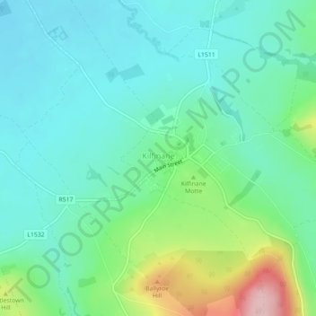
Nome: Mappa topografica Kilfinnane, altitudine, rilievo.
Altitudine media: 160 m
Altitudine minima: 108 m
Altitudine massima: 316 m
Altre mappe topografiche
Clicca su una mappa per visualizzarne la topografia, l'altitudine e il rilievo.
Galtymore
Ireland > County Limerick > The Municipal District of Cappamore — Kilmallock
Galtymore or Galteemore (Irish: Cnoc Mór na nGaibhlte, meaning 'big hill of the Galtees') is a mountain in the province of Munster, Ireland. At 917.9 metres (3,011 ft 6 in), it is one of Ireland's highest mountains, being the 12th-highest on the Arderin list, and 14th-highest on the Vandeleur-Lynam list.…
Altitudine media: 594 m
Aherlow
Ireland > County Limerick > The Municipal District of Cappamore — Kilmallock
Altitudine media: 141 m
Kilcruaig
Ireland > County Limerick > The Municipal District of Cappamore — Kilmallock
Altitudine media: 200 m
Knockadea
Ireland > County Limerick > The Municipal District of Cappamore — Kilmallock
Altitudine media: 203 m
Pallasgreen
Ireland > County Limerick > The Municipal District of Cappamore — Kilmallock
Altitudine media: 72 m
Clare Glens
Ireland > County Limerick > The Municipal District of Cappamore — Kilmallock
Altitudine media: 124 m
Ardpatrick
Ireland > County Limerick > The Municipal District of Cappamore — Kilmallock
Altitudine media: 169 m
Bruff
Ireland > County Limerick > The Municipal District of Cappamore — Kilmallock
Altitudine media: 68 m
Bruree
Ireland > County Limerick > The Municipal District of Cappamore — Kilmallock
Altitudine media: 62 m