
Mappa topografica Reti Bandar
Clicca sulla mappa per visualizzare l'altitudine.
A proposito di questa mappa
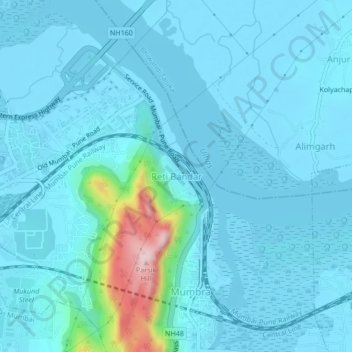
Nome: Mappa topografica Reti Bandar, altitudine, rilievo.
Altitudine media: 29 m
Altitudine minima: -2 m
Altitudine massima: 298 m
Altre mappe topografiche
Clicca su una mappa per visualizzarne la topografia, l'altitudine e il rilievo.
Sanjay Gandhi National Park
India > Maharashtra > Thane Taluka > Thane
The region is hilly with elevations between 30 and 480 m (98 and 1,575 ft). Vihar Lake and Tulsi Lake in the park meet a part of the city's water requirements. The park is said to be the lungs of the city as it purifies much of the air pollution in the city.
Altitudine media: 42 m