
Mappa topografica Holderness
Mappa interattiva
Clicca sulla mappa per visualizzare l'altitudine.
A proposito di questa mappa
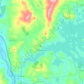
Nome: Mappa topografica Holderness, altitudine, rilievo.
Altitudine media: 252 m
Altitudine minima: 138 m
Altitudine massima: 648 m
According to the United States Census Bureau, the town has a total area of 35.6 square miles (92 km2), of which 30.4 sq mi (79 km2) is land and 5.2 sq mi (13 km2) is water, comprising 14.73% of the town. Bounded on the northwest by the Pemigewasset River, Holderness is drained by Owl Brook. Part of Squam Lake is in the east, and Little Squam Lake is in the center. Mount Prospect, with an elevation of 2,064 feet (629 m) above sea level, is in the north. Also in the north is the highest point in Holderness, Mount Webster, elevation 2,076 feet (633 m) and part of the Squam Range. Holderness lies fully within the Merrimack River watershed.