
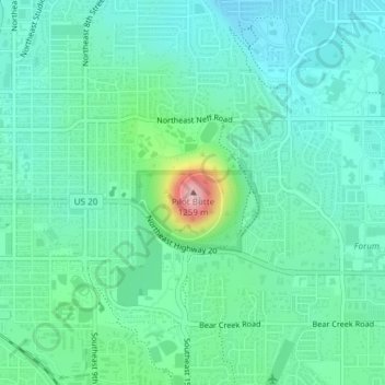
Mappa topografica Pilot Butte
Mappa interattiva
Clicca sulla mappa per visualizzare l'altitudine.
A proposito di questa mappa
Nome: Mappa topografica Pilot Butte, altitudine, rilievo.
Altitudine media: 1’113 m
Altitudine minima: 1’071 m
Altitudine massima: 1’260 m
The 114.22-acre (46.22-hectare) Pilot Butte State Scenic Viewpoint, presented as a gift to the State of Oregon in 1928, is a Bend icon. Pilot Butte itself is a popular hiking destination with two trails to the summit, each gaining about 490 feet (150 m) in elevation. There is also a 1.8-mile (2.9 km) trail around the base of the butte. A scenic road also winds up and around the cone. In 2018, the park was the most visited Oregon state park east of the Cascade Mountains. From the top, the entire city of Bend is visible, as well as several major Cascade peaks. Most prominent are the Three Sisters, Broken Top, and Mount Bachelor, which are located about 20 miles (32 km) to the west. The City of Bend launches Fourth of July fireworks from Pilot Butte each year.
Altre mappe topografiche
Clicca su una mappa per visualizzarne la topografia, l'altitudine e il rilievo.
Archie Briggs Canyon Natural Area
United States > Oregon > Deschutes County > Bend
Archie Briggs Canyon Natural Area, Northwest Falcon Ridge, Bend, Deschutes County, Oregon, 97703, United States
Altitudine media: 1’115 m