
Mappa topografica Willey
Clicca sulla mappa per visualizzare l'altitudine.
A proposito di questa mappa
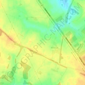
Nome: Mappa topografica Willey, altitudine, rilievo.
Luogo: Willey, Warwickshire, England, United Kingdom (52.44931 -1.29861 52.47201 -1.25293)
Altitudine media: 123 m
Altitudine minima: 103 m
Altitudine massima: 136 m
Altre mappe topografiche
Clicca su una mappa per visualizzarne la topografia, l'altitudine e il rilievo.
Ashorne
United Kingdom > England > Warwickshire > Stratford-on-Avon > Moreton Morrell
Altitudine media: 67 m
Brook End
United Kingdom > England > Warwickshire > North Warwickshire > Hurley
Altitudine media: 107 m
Tanworth in Arden CP
United Kingdom > England > Warwickshire > Stratford-on-Avon
Altitudine media: 139 m
Warwick
United Kingdom > England > Warwickshire
Warwick experiences the usual English maritime climate, marked by a narrow temperature range, mild winters and cool summers. The nearest official Met Office weather station is at Wellesbourne, about 6 miles (10 km) south of the town centre and at a similar elevation. The absolute maximum temperature (also the…
Altitudine media: 87 m
Stratford-upon-Avon
United Kingdom > England > Warwickshire > Stratford-on-Avon
Altitudine media: 61 m
Gilson
United Kingdom > England > Warwickshire > North Warwickshire > Coleshill CP
Altitudine media: 82 m
Napton on the Hill
United Kingdom > England > Warwickshire > Stratford-on-Avon
Altitudine media: 113 m
Brailes
United Kingdom > England > Warwickshire > Stratford-on-Avon > Lower Brailes
Altitudine media: 139 m
Hampton on the Hill
United Kingdom > England > Warwickshire > Warwick > Hampton on the Hill
Altitudine media: 75 m
Bishops Itchington
United Kingdom > England > Warwickshire > Stratford-on-Avon
Altitudine media: 104 m
Birmingham and Fazeley Canal
United Kingdom > England > Warwickshire > Minworth
Altitudine media: 105 m
Upper Quinton
United Kingdom > England > Warwickshire > Stratford-on-Avon > Lower Quinton
Altitudine media: 70 m
Lye Green
United Kingdom > England > Warwickshire > Stratford-on-Avon > Claverdon
Altitudine media: 106 m
Priors Hardwick CP
United Kingdom > England > Warwickshire > Stratford-on-Avon
Altitudine media: 134 m
Cranhill
United Kingdom > England > Warwickshire > Stratford-on-Avon > Ardens Grafton
Altitudine media: 57 m
Curdworth Locks
United Kingdom > England > Warwickshire > North Warwickshire > Kingsbury > Curdworth CP
Altitudine media: 80 m