

Mappa topografica Lancaster
Clicca sulla mappa per visualizzare l'altitudine.
Lancaster
According to the United States Census Bureau, the city has a total area of 94.5 square miles (245 km2), of which 94.3 square miles (244 km2) is land and 0.3 square miles (0.78 km2) (0.29%) is water. Lancaster's elevation is 2,350 feet (720 m) above sea level on a high, flat valley surrounded by pristine mountain ranges. Because the elevation is in the range of 2,000 to 3,000 feet (600–900 m) above sea level, the area, like the other parts of the Mojave Desert region, is alternatively referred to as the High Desert. Some cities and communities within the trading area of Lancaster include Palmdale, Rosamond, Lake Los Angeles, Quartz Hill, Ridgecrest, and Santa Clarita. Residents of these desert cities and unincorporated communities share Sierra Highway, Angeles Forest Highway, Angeles Crest Highway (State Route 2), and the Antelope Valley Freeway (State Route 14) for commutes to the San Fernando Valley and Los Angeles Basin.
A proposito di questa mappa
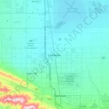
Nome: Mappa topografica Lancaster, altitudine, rilievo.
Luogo: Lancaster, Los Angeles County, California, United States (34.63095 -118.32518 34.76886 -117.93867)
Altitudine media: 787 m
Altitudine minima: 691 m
Altitudine massima: 1’590 m
Altre mappe topografiche
Clicca su una mappa per visualizzarne la topografia, l'altitudine e il rilievo.
Lancaster
United States > California > Lancaster
According to the United States Census Bureau, the city has a total area of 94.5 square miles (245 km2), of which 94.3 square miles (244 km2) is land and 0.3 square miles (0.78 km2) (0.29%) is water. Lancaster's elevation is 2,350 feet (720 m) above sea level on a high, flat valley surrounded by pristine…
Altitudine media: 789 m