
Mappa topografica Gorges State Park
Mappa interattiva
Clicca sulla mappa per visualizzare l'altitudine.
A proposito di questa mappa
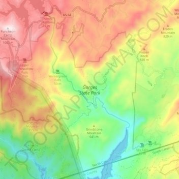
Nome: Mappa topografica Gorges State Park, altitudine, rilievo.
Altitudine media: 682 m
Altitudine minima: 329 m
Altitudine massima: 1’081 m
Following the flood, local citizens eventually sold large land tracts in the Gorges to Singer Sewing Machine Company, which logged most of the land. Then, in the 1940s and 1950s, Singer sold the land to Duke Energy Corporation. The corporation purchased the land for its steep topography and high rainfall, which offered opportunities for development of hydropower projects.
Altre mappe topografiche
Clicca su una mappa per visualizzarne la topografia, l'altitudine e il rilievo.
Middle Mountain
United States > North Carolina > Transylvania County
Middle Mountain, Transylvania County, North Carolina, United States
Altitudine media: 916 m
Brevard
United States > North Carolina > Transylvania County
Brevard, Transylvania County, North Carolina, United States
Altitudine media: 745 m
North Brevard
United States > North Carolina > Transylvania County > North Brevard
North Brevard, Transylvania County, North Carolina, 28768, United States
Altitudine media: 673 m