
Mappa topografica Coniston Water
Clicca sulla mappa per visualizzare l'altitudine.
Coniston Water
Coniston Water in the English county of Cumbria is the third-largest lake in the Lake District by volume (after Windermere and Ullswater), and the fifth-largest by area. It is five miles long by half a mile wide (8 km by 800 m), has a maximum depth of 184 feet (56 m), and covers an area of 1.89 square miles (4.9 km2). The lake has an elevation of 143 feet (44 m) above sea level. It drains to the sea via the River Crake.
A proposito di questa mappa
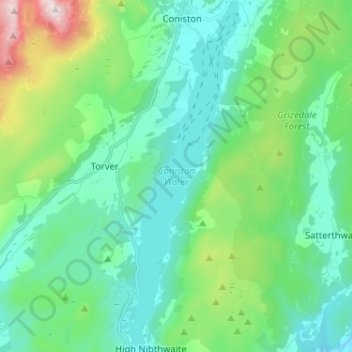
Nome: Mappa topografica Coniston Water, altitudine, rilievo.
Altitudine media: 186 m
Altitudine minima: 17 m
Altitudine massima: 791 m
Altre mappe topografiche
Clicca su una mappa per visualizzarne la topografia, l'altitudine e il rilievo.
Whitestone Moss
United Kingdom > England > Cumbria > South Lakeland > High Nibthwaite > Houkler Hall
Altitudine media: 102 m