
Mappa topografica Buntzen Lake
Mappa interattiva
Clicca sulla mappa per visualizzare l'altitudine.
A proposito di questa mappa
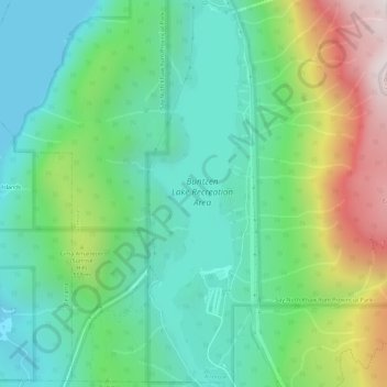
Nome: Mappa topografica Buntzen Lake, altitudine, rilievo.
Altitudine media: 348 m
Altitudine minima: 0 m
Altitudine massima: 1’158 m
Hiking time: 6–8 hours return. Distance: 15 km (9 mi). Elevation gain: 1,020 m (3,350 ft). This is the most popular of the three Halvor Lunden trails. It passes thought ancient mountain forests and has a number of viewpoints from which overlook Vancouver. The trailhead is on Powerhouse Road, near the southeast corner of the South Beach parking area, and takes you up a steep climb of over 700m, passing the Polytrichum Lookout before reaching the "Lake district" which includes several small lakes and the larger Lindsay Lake.
Altre mappe topografiche
Clicca su una mappa per visualizzarne la topografia, l'altitudine e il rilievo.
Buntzen Bay
Canada > British Columbia > Metro Vancouver Regional District > Anmore
Buntzen Bay, Anmore, Metro Vancouver Regional District, British Columbia, Canada
Altitudine media: 214 m
Burrard Inlet
Canada > British Columbia > Metro Vancouver Regional District > Anmore
Burrard Inlet, Anmore, District of North Vancouver, Metro Vancouver Regional District, British Columbia, Canada
Altitudine media: 478 m