
Mappa topografica Tarkastad
Mappa interattiva
Clicca sulla mappa per visualizzare l'altitudine.
A proposito di questa mappa
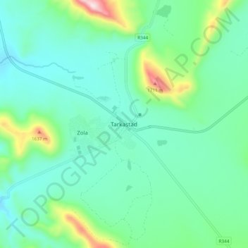
Nome: Mappa topografica Tarkastad, altitudine, rilievo.
Altitudine media: 1’347 m
Altitudine minima: 1’228 m
Altitudine massima: 1’777 m
Scientists have stated that Tarkastad has one of the healthiest climates in the world. Winters are cold with frequent snowfalls on high lying mountain tops, while summers are hot and dry. Tarkastad which is situated at an elevation of 1,304 metres normally receives about 335mm of rain per year, with most rainfall occurring mainly during summer.
Altre mappe topografiche
Clicca su una mappa per visualizzarne la topografia, l'altitudine e il rilievo.
Elandskop
South Africa > Eastern Cape > Chris Hani District Municipality > Tsolwana Local Municipality
Elandskop, Tsolwana Local Municipality, Chris Hani District Municipality, Eastern Cape, South Africa
Altitudine media: 1’386 m