
Mappa topografica Kachess Lake
Mappa interattiva
Clicca sulla mappa per visualizzare l'altitudine.
A proposito di questa mappa
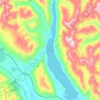
Nome: Mappa topografica Kachess Lake, altitudine, rilievo.
Luogo: Kachess Lake, Kittitas County, Washington, United States (47.26445 -121.25551 47.40491 -121.18733)
Altitudine media: 1’090 m
Altitudine minima: 677 m
Altitudine massima: 1’770 m
The lake is used as a storage reservoir for the Yakima Project, an irrigation project run by the United States Bureau of Reclamation. Although a natural lake, Kachess Lake's capacity and discharge is controlled by Kachess Dam, a 115-foot (35 m) high earthfill structure built in 1912. The discharge channel for Kachess Reservoir is 2,877 feet long and was constructed from the natural lake to the intake structure of the dam's outlet works, approximately 1800 feet downstream and at a lower elevation than the original lake outlet. The intent of the lowered outlet works was to put all of the average annual runoff into service by adding an additional 76,000 acre feet of natural lake water. As a storage reservoir, Kachess Lake's active capacity is 239,000 acre⋅ft (295 million m3).
Altre mappe topografiche
Clicca su una mappa per visualizzarne la topografia, l'altitudine e il rilievo.
Ellensburg
United States > Washington > Kittitas County > Ellensburg > Ellensburg
Ellensburg, Kittitas County, Washington, 98926, United States
Altitudine media: 485 m
Snoqualmie Pass
United States > Washington > Kittitas County
Snoqualmie Pass, Kittitas County, Washington, United States
Altitudine media: 955 m
Ellensburg
United States > Washington > Kittitas County
Ellensburg, Kittitas County, Washington, 98926, United States
Altitudine media: 480 m
Vantage
United States > Washington > Kittitas County
Vantage, Kittitas County, Washington, United States
Altitudine media: 218 m
Four Brothers
United States > Washington > Kittitas County
Four Brothers, Kittitas County, Washington, United States
Altitudine media: 1’577 m