
Mappa topografica Augusta
Mappa interattiva
Clicca sulla mappa per visualizzare l'altitudine.
Augusta
As with the rest of the state, Augusta has a humid subtropical climate (Köppen Cfa), with short, mild winters, very hot, humid summers, and a wide diurnal temperature variation throughout much of the year, despite its low elevation and humidity. The monthly daily average temperature ranges from 45.4 °F (7.4 °C) in January to 81.6 °F (27.6 °C) in July; there are 53 nights with the low reaching the freezing mark, 82 days reaching or exceeding 90 °F (32 °C), and 5.5 days reaching 100 °F (38 °C) annually. Extreme temperatures range from −1 °F (−18 °C) on January 21, 1985 up to 108 °F (42 °C) on August 10, 2007, and August 21, 1983. Snowfall is not nearly as common as in Atlanta, due largely to Augusta's elevation, with downtown Augusta being about 900 ft (270 m) lower than downtown Atlanta. The heaviest recorded snowfall was in February 1973 with 14.0″ snowfall (35.56 cm)[19] Freezing rain is also a threat in wintertime.
A proposito di questa mappa
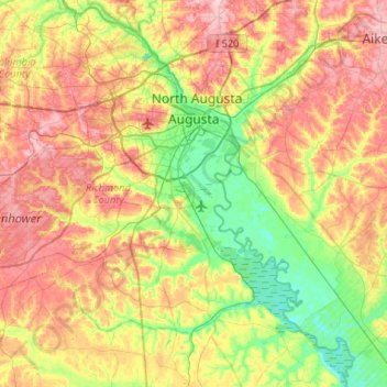
Nome: Mappa topografica Augusta, altitudine, rilievo.
Luogo: Augusta, Richmond County, Georgia, United States (33.22717 -82.35387 33.54502 -81.82812)
Altitudine media: 89 m
Altitudine minima: 21 m
Altitudine massima: 177 m
Altre mappe topografiche
Clicca su una mappa per visualizzarne la topografia, l'altitudine e il rilievo.
Berckman Villas
United States > Georgia > Richmond County > Augusta > Berckman Villas
Altitudine media: 87 m