
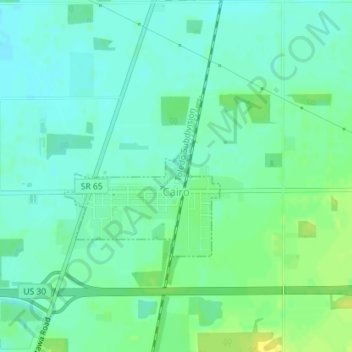
Mappa topografica Cairo
Mappa interattiva
Clicca sulla mappa per visualizzare l'altitudine.
A proposito di questa mappa
Nome: Mappa topografica Cairo, altitudine, rilievo.
Luogo: Cairo, Allen County, Ohio, 45820, United States (40.82698 -84.09318 40.83927 -84.07743)
Altitudine media: 249 m
Altitudine minima: 241 m
Altitudine massima: 261 m
The elevation of the land area of Cairo (ranges from about 812' at the west end to 842' at the east end of the village above sea level) is benchmarked at 815 feet (248 m) above sea level, generally flat and moderately wooded. The nearest stream with year-round flow is Rattlesnake Creek, which flows from south of the village and passes just to the west of the village. Water flow in the village is generally from the south and east to the north and west.
Altre mappe topografiche
Clicca su una mappa per visualizzarne la topografia, l'altitudine e il rilievo.
Lima
United States > Ohio > Allen County
Lima, Allen County, Ohio, 45804, United States
Altitudine media: 267 m
Spencerville
United States > Ohio > Allen County
Spencerville, Allen County, Ohio, 45887, United States
Altitudine media: 254 m
Bluffton
United States > Ohio > Allen County
Bluffton, Allen County, Ohio, 45817, United States
Altitudine media: 255 m
Delphos
United States > Ohio > Allen County
Delphos, Allen County, Ohio, 45833, United States
Altitudine media: 236 m
Maysville
United States > Ohio > Allen County
Maysville, Jackson Township, Allen County, Ohio, United States
Altitudine media: 307 m
Kemp
United States > Ohio > Allen County
Kemp, Allen County, Ohio, United States
Altitudine media: 256 m
Landeck
United States > Ohio > Allen County
Landeck, Allen County, Ohio, United States
Altitudine media: 242 m
Scotts Crossing
United States > Ohio > Allen County
Scotts Crossing, Allen County, Ohio, United States
Altitudine media: 239 m
Hume
United States > Ohio > Allen County
Hume, Allen County, Ohio, United States
Altitudine media: 260 m
Gomer
United States > Ohio > Allen County
Gomer, Allen County, Ohio, 45809, United States
Altitudine media: 237 m
West Newton
United States > Ohio > Allen County
West Newton, Auglaize Township, Allen County, Ohio, United States
Altitudine media: 316 m
Southworth
United States > Ohio > Allen County
Southworth, Allen County, Ohio, United States
Altitudine media: 247 m
South Warsaw
United States > Ohio > Allen County
South Warsaw, Perry Township, Allen County, Ohio, United States
Altitudine media: 283 m
Rockport
United States > Ohio > Allen County
Rockport, Monroe Township, Allen County, Ohio, 45830, United States
Altitudine media: 248 m
Conant
United States > Ohio > Allen County
Conant, Allen County, Ohio, United States
Altitudine media: 251 m
Allentown
United States > Ohio > Allen County > Lima
Allentown, Lima, Allen County, Ohio, 45805, United States
Altitudine media: 250 m
Westminster
United States > Ohio > Allen County
Westminster, Auglaize Township, Allen County, Ohio, United States
Altitudine media: 294 m
Elida
United States > Ohio > Allen County
Elida, Allen County, Ohio, United States
Altitudine media: 244 m
Beaverdam
United States > Ohio > Allen County
Beaverdam, Allen County, Ohio, 45808, United States
Altitudine media: 264 m
Fort Shawnee
United States > Ohio > Allen County
Fort Shawnee, Allen County, Ohio, 45806, United States
Altitudine media: 268 m
Lafayette
United States > Ohio > Allen County
Lafayette, Allen County, Ohio, 45854, United States
Altitudine media: 286 m
Lima
United States > Ohio > Allen County
Lima, Allen County, Ohio, 45804, United States
Altitudine media: 267 m
Harrod
United States > Ohio > Allen County
Harrod, Allen County, Ohio, United States
Altitudine media: 305 m