
Fai una donazione
Equipaggiati per la tua prossima avventura:
In qualità di Affiliato Amazon, questo sito riceve una commissione sugli acquisti idonei, senza costi aggiuntivi per l’utente.
Mappa topografica Gaya
Clicca sulla mappa per visualizzare l'altitudine.
Fai una donazione
Equipaggiati per la tua prossima avventura:
In qualità di Affiliato Amazon, questo sito riceve una commissione sugli acquisti idonei, senza costi aggiuntivi per l’utente.
Gaya
Gaya is connected to the rest of India by roads, rail and airways. The Grand Chord section of the Indian Railways passes through Gaya. Gaya Junction railway station railway station is a major junction station serving the city. Gaya Junction has been redeveloped as Model railway station recently and houses all the major facilities like waiting rooms, computerized reservation facility, food plaza, dormitory, retiring rooms, cafeteria, bookshop, etc. Gaya falls under the jurisdiction of the Mughalsarai railway division of the East Central Railway zone. The Grand Chord rail line that connects Howrah and New Delhi passes through Gaya. It lies between Mughalsarai Junction on the Delhi side and Dhanbad Junction on the Howrah side. It is located at 24°48′13″N 84°59′57″E / 24.80361°N 84.99917°E / 24.80361; 84.99917. It has an elevation of 117 metres (384 ft).
Fai una donazione
Equipaggiati per la tua prossima avventura:
In qualità di Affiliato Amazon, questo sito riceve una commissione sugli acquisti idonei, senza costi aggiuntivi per l’utente.
A proposito di questa mappa
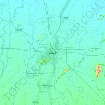
Nome: Mappa topografica Gaya, altitudine, rilievo.
Luogo: Gaya, Gaya Town C.D.Block, Gaya, Bihar, 823001, India (24.63644 84.84796 24.95644 85.16796)
Altitudine media: 111 m
Altitudine minima: 81 m
Altitudine massima: 480 m
Fai una donazione
Equipaggiati per la tua prossima avventura:
In qualità di Affiliato Amazon, questo sito riceve una commissione sugli acquisti idonei, senza costi aggiuntivi per l’utente.