
Mappa topografica Tiverton
Mappa interattiva
Clicca sulla mappa per visualizzare l'altitudine.
A proposito di questa mappa
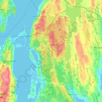
Nome: Mappa topografica Tiverton, altitudine, rilievo.
Luogo: Tiverton, Newport County, Rhode Island, 02878, United States (41.54544 -71.22130 41.67509 -71.12784)
Altitudine media: 31 m
Altitudine minima: -5 m
Altitudine massima: 93 m
Much of the town is located along a granite ridge which runs in a north–south direction, rising approximately 170 feet in elevation from the bay. A large section of exposed granite can be observed at the highway cut for Route 24, near the Main Road interchange.
Altre mappe topografiche
Clicca su una mappa per visualizzarne la topografia, l'altitudine e il rilievo.
Portsmouth
United States > Rhode Island > Newport County
Portsmouth, Newport County, Rhode Island, United States
Altitudine media: 19 m
Fort Wetherill
United States > Rhode Island > Newport County > Jamestown
Fort Wetherill, Highland Drive, Jamestown, Newport County, Rhode Island, 02835, United States
Altitudine media: 4 m
Aquidneck Island
United States > Rhode Island > Newport County > Portsmouth
Aquidneck Island, Portsmouth, Newport County, Rhode Island, United States
Altitudine media: 13 m
Newport
United States > Rhode Island > Newport County
Newport, Newport County, Rhode Island, 02840, United States
Altitudine media: 8 m
Pocasset Hill
United States > Rhode Island > Newport County > Tiverton
Pocasset Hill, Tiverton, Newport County, Rhode Island, 02878, United States
Altitudine media: 51 m
Jamestown
United States > Rhode Island > Newport County
Jamestown, Newport County, Rhode Island, 02835, United States
Altitudine media: 8 m
Middletown
United States > Rhode Island > Newport County
Middletown, Newport County, Rhode Island, 02842, United States
Altitudine media: 19 m
Little Compton
United States > Rhode Island > Newport County
Little Compton, Newport County, Rhode Island, United States
Altitudine media: 9 m