
Mappa topografica Cedar City
Mappa interattiva
Clicca sulla mappa per visualizzare l'altitudine.
A proposito di questa mappa
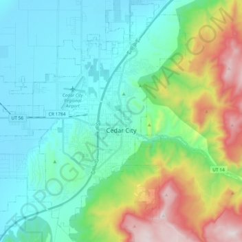
Nome: Mappa topografica Cedar City, altitudine, rilievo.
Luogo: Cedar City, Iron County, Utah, United States (37.61847 -113.19797 37.74748 -113.01272)
Altitudine media: 1’975 m
Altitudine minima: 1’676 m
Altitudine massima: 2’866 m
Cedar City is located in the southeast Great Basin and is approximately 20 miles (32 km) north of the northeastern edge of the Mojave Desert. Its elevation of 5,846 feet (1,782 m) gives it a somewhat cooler climate compared to the nearby St. George region, though it retains cultural ties to the city —for example, they share a daily newspaper.
Altre mappe topografiche
Clicca su una mappa per visualizzarne la topografia, l'altitudine e il rilievo.
The Three Peaks
United States > Utah > Iron County
The Three Peaks, Iron County, Utah, United States
Altitudine media: 1’789 m
Brian Head
United States > Utah > Iron County
Brian Head, Iron County, Utah, 84719, United States
Altitudine media: 3’031 m
Cedar Breaks
United States > Utah > Iron County
Cedar Breaks, Iron County, Utah, United States
Altitudine media: 2’843 m
Newcastle
United States > Utah > Iron County
Newcastle, Iron County, Utah, United States
Altitudine media: 1’640 m
Cedar City
United States > Utah > Iron County > Cedar City > Cedar City
Cedar City, Iron County, Utah, 84720, United States
Altitudine media: 2’087 m
Beryl
United States > Utah > Iron County
Beryl, Iron County, Utah, United States
Altitudine media: 1’573 m
Enoch
United States > Utah > Iron County
Enoch, Iron County, Utah, United States
Altitudine media: 1’769 m
Strawberry Point
United States > Utah > Iron County
Strawberry Point, Iron County, Utah, 84772, United States
Altitudine media: 2’436 m
Kanarraville
United States > Utah > Iron County
Kanarraville, Iron County, Utah, 84742, United States
Altitudine media: 1’721 m
Parowan
United States > Utah > Iron County
Parowan, Iron County, Utah, 84761, United States
Altitudine media: 2’002 m