
Mappa topografica Utqiaġvik
Mappa interattiva
Clicca sulla mappa per visualizzare l'altitudine.
A proposito di questa mappa
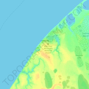
Nome: Mappa topografica Utqiaġvik, altitudine, rilievo.
Luogo: Utqiaġvik, North Slope, Alaska, 99273, United States (71.23029 -156.92450 71.34026 -156.63934)
Altitudine media: 4 m
Altitudine minima: 0 m
Altitudine massima: 18 m
Despite the extreme northern location, temperatures at Utqiagvik are moderated by the surrounding topography. The Arctic Ocean is on three sides, and flat tundra stretches some 200 mi (320 km) to the south. No wind barriers or protected valleys exist where dense cold air can settle or form temperature inversions in the lower atmosphere, as commonly happens in the interior between the Brooks and the Alaska ranges.[32]
Altre mappe topografiche
Clicca su una mappa per visualizzarne la topografia, l'altitudine e il rilievo.
Prudhoe Bay
United States > Alaska > North Slope
Prudhoe Bay, North Slope, Alaska, 99734, United States
Altitudine media: 10 m
Toolik Field Station
United States > Alaska > North Slope
Toolik Field Station, North Slope, Alaska, United States
Altitudine media: 740 m
Chandalar Shelf
United States > Alaska > North Slope
Chandalar Shelf, North Slope, Alaska, United States
Altitudine media: 974 m
Toolik River
United States > Alaska > North Slope
Toolik River, North Slope, Alaska, United States
Altitudine media: 126 m
Kaktovik
United States > Alaska > North Slope > Kaktovik
Kaktovik, North Slope, Alaska, 99747, United States
Altitudine media: 5 m
Point Barrow
United States > Alaska > North Slope
Point Barrow, North Slope, Alaska, United States
Altitudine media: 0 m
Deadhorse
United States > Alaska > North Slope
Deadhorse, North Slope, Alaska, 99734, United States
Altitudine media: 14 m