
Mappa topografica Roan Mountain
Mappa interattiva
Clicca sulla mappa per visualizzare l'altitudine.
Roan Mountain
Roan Mountain is located in northeast Tennessee at 36°11′39″N 82°4′6″W / 36.19417°N 82.06833°W / 36.19417; -82.06833 (36.194219, -82.068417). According to the United States Census Bureau, the CDP has a total area of 6.6 square miles (17.2 km2), all land. The elevation of Roan Mountain near the center of the CDP is 2,550 feet (780 m).
A proposito di questa mappa
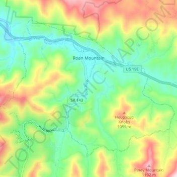
Nome: Mappa topografica Roan Mountain, altitudine, rilievo.
Altitudine media: 926 m
Altitudine minima: 760 m
Altitudine massima: 1’210 m